IMAGES TAKEN NEAR TO
Horsham Road, WORTHING, BN14 0TF
Introduction
This page details the photographs taken nearby to Horsham Road, BN14 0TF by members of the Geograph project.
The Geograph project started in 2005 with the aim of publishing, organising and preserving representative images for every square kilometre of Great Britain, Ireland and the Isle of Man.

There are currently over 7.5m images from over14,400 individuals and you can help contribute to the project by visiting https://www.geograph.org.uk
Image Map
Images are licensed for reuse under creativecommons.org/licenses/by-sa/2.0
Notes
- Clicking on the map will re-center to the selected point.
- The higher the marker number, the further away the image location is from the centre of the postcode.
Image Listing (95 Images Found)
Images are licensed for reuse under creativecommons.org/licenses/by-sa/2.0
Image
Details
Distance
1
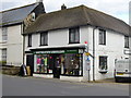
Findon Post Office
Located on Horsham Road just to the north of Image The post office occupies the former Findon Farmhouse.
Image: © Simon Carey
Taken: 13 Jul 2013
0.01 miles
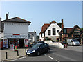
3
Findon Farmhouse, Horsham Road
The former farmhouse lies between the post office and saddlery just north of The Square and dates from the early 19th century. It remained a working farm up until the early 1960s when it finally closed and much of the surrounding fields were sold off to develop many of the current housing estates and closes. Beyond is Image which was the site of the farm's barns and outbuildings. To the right is the Village House a building which dates from the 16h century but has only been a pub from the last century.
Image: © Simon Carey
Taken: 20 Jul 2013
0.01 miles
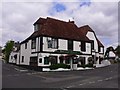
4
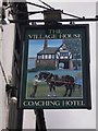
The Village House, Findon
One of four pubs in the village of Findon and dates from the 16th century.
Image: © Richard Rogerson
Taken: 10 May 2017
0.01 miles
6
The Village House Findon
Located beside the cross roads in the centre of the village.
Image: © Chris Thomas-Atkin
Taken: 26 Nov 2018
0.02 miles
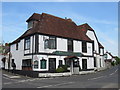
8
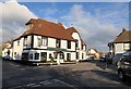
Findon High Street
The crossroads at the centre of Findon has pubs on either side of it: the Gun in the foreground and the Village House beyond.
Image: © Christopher Hilton
Taken: 24 Jan 2015
0.02 miles
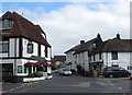
9
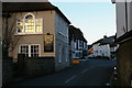
The Square, Findon
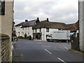
Looking north from outside the Gun Inn. School Lane crosses immediately ahead, and beyond it the High Street continues as the Horsham Road. Straight ahead, on the opposite corner, is the Southdown Saddlery, with the local post office to the left, while behind the delivery van is the village butcher's shop.
I think it's worth pointing out that within living memory this quiet village street was the main London-Worthing road. According to Valerie Martin's excellent village website, Findon by-pass was completed in 1939: http://www.findonvillage.com/0055_the_train_takes_the_strain.htm
Image: © Stefan Czapski
Taken: 8 Nov 2012
0.02 miles
10
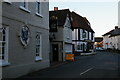
Southdown Saddlery, The Square, Findon
I happened to go into this shop to ask directions to Cissbury Ring. There are waxed jackets and the like in the window, but it was a pleasant surprise to discover that the owner is a skilled craftswoman, with a small workshop at the back of the premises.
The Saddlery's website tells me that Katie Jones served a full 7-year apprenticeship before setting up her own business here in Findon. But she makes it clear that she's not too proud to turn her hand to non- equestrian work - even the odd handbag repair: http://www.southdownsaddlery.com/aboutus.asp
Image: © Stefan Czapski
Taken: 8 Nov 2012
0.02 miles