IMAGES TAKEN NEAR TO
Long Meadow, WORTHING, BN14 0HU
Introduction
This page details the photographs taken nearby to Long Meadow, BN14 0HU by members of the Geograph project.
The Geograph project started in 2005 with the aim of publishing, organising and preserving representative images for every square kilometre of Great Britain, Ireland and the Isle of Man.

There are currently over 7.5m images from over14,400 individuals and you can help contribute to the project by visiting https://www.geograph.org.uk
Image Map
Images are licensed for reuse under creativecommons.org/licenses/by-sa/2.0
Notes
- Clicking on the map will re-center to the selected point.
- The higher the marker number, the further away the image location is from the centre of the postcode.
Image Listing (23 Images Found)
Images are licensed for reuse under creativecommons.org/licenses/by-sa/2.0
Image
Details
Distance
1
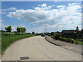
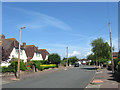
Long Meadow, Findon Valley
A residential road that runs from Storrington Rise to Central Avenue that was developed in the 1960s. Findon Valley is the northernmost suburb of Worthing and was developed from the 1930s onwards after parts of the arrea was transferred from the parish of Findon in 1933. The road itself is now a boundary between suburbia and the South Downs National Park.
Image: © Simon Carey
Taken: 2 Jun 2013
0.02 miles
2
Sullington Gardens, Findon Valley
A residential road linking Storrington Rise to Central Avenue. Fondon Valley is the northern most suburb of Worthing and was developed towards the end of the 1930s having been transferred from the parish of Findon in 1933.
Image: © Simon Carey
Taken: 2 Jun 2013
0.06 miles
3

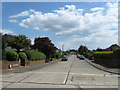
Storrington Rise, Findon Valley
A residential road that links Maytree Avenue with Long Meadow. Findon Valley is the northern most suburb of Worthing parts of which were transferred from the parish of Findon in 1933. Previously a field called The Four Acres, Storrington Rise was laid out towards the end of the 1930s though building was not completed until after the Second World War.
Image: © Simon Carey
Taken: 2 Jun 2013
0.11 miles
4
Storrington Rise Car Park at base of Cissbury Ring: Findon
Situated in the NE corner of the grid square, the walk to the ring starts here and in less than one kilometre one gets to the ring.
Image: © Pam Brophy
Taken: 16 Apr 2005
0.13 miles
6
Hazelhurst Crescent, Findon Valley
A residential road connecting Central Avenue to May Tree Avenue which was developed during the 1930s after this part of the parish was transferred to Worthing.
Image: © Simon Carey
Taken: 30 Jun 2013
0.15 miles
7
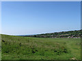
Honey Bittums (1)
The name of the field according to Findon's 1839 tithe map that lies between the western slopes of Cissbury Ring and the suburb of Findon Valley. This part of the parish was transferred to Worthing Borough Council in 1933 and the field these days is open access and a popular spot for locals to walk their dogs. See also Image
Image: © Simon Carey
Taken: 2 Jun 2013
0.15 miles
8

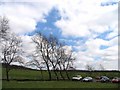
Bridleway at the rear of houses on Storrington Rise
Image: © Dave Spicer
Taken: 27 Sep 2009
0.15 miles
9
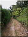
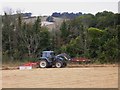
Bridleway at Findon
This bridleway is behind the houses in Storrington Rise and leads to the A24.
Image: © Shazz
Taken: 30 Jul 2010
0.16 miles
10

Honey Bittums (2)
The name of the field according to Findon's 1839 tithe map viewed from the south west corner. All of the field along with adjacent ones bordering onto the Findon Valley suburbs are now open space and popular with the locals. Hill barn Covert is the wood at the far end of the field which lies on the slopes of Cissbury Ring. See also Image
Image: © Simon Carey
Taken: 30 Jun 2013
0.18 miles