IMAGES TAKEN NEAR TO
Findon Road, WORTHING, BN14 0BG
Introduction
This page details the photographs taken nearby to Findon Road, BN14 0BG by members of the Geograph project.
The Geograph project started in 2005 with the aim of publishing, organising and preserving representative images for every square kilometre of Great Britain, Ireland and the Isle of Man.

There are currently over 7.5m images from over14,400 individuals and you can help contribute to the project by visiting https://www.geograph.org.uk
Image Map
Images are licensed for reuse under creativecommons.org/licenses/by-sa/2.0
Notes
- Clicking on the map will re-center to the selected point.
- The higher the marker number, the further away the image location is from the centre of the postcode.
Image Listing (14 Images Found)
Images are licensed for reuse under creativecommons.org/licenses/by-sa/2.0
Image
Details
Distance
1
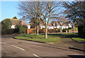
Top of Uplands Avenue
Looking to Woodland Avenue, High Salvington.
Image: © Andrew Hill
Taken: 27 Jan 2009
0.08 miles
2
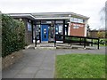
Findon Valley Library, Lime Tree Avenue, BN14 0DH
Built in 1958.
Image: © Peter Holmes
Taken: 19 Mar 2019
0.09 miles

4
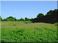
Southernmost part of The Gallops, Findon Valley
This part of The Gallops is divided from the northern grassy open area by a stretch of woodland. All parts are popular with cyclists, horse riders and dog walkers.
Image: © Slbs
Taken: 19 Jun 2008
0.16 miles
5

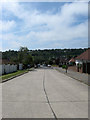
Findon Road
The A24, looking North from a coach.
Image: © Martin Addison
Taken: 11 Aug 2018
0.17 miles
6
Parham Road
Looking from the end, where there is a pedestrian gate into Durrington Cemetery.
Image: © Robin Webster
Taken: 26 Feb 2010
0.18 miles
7
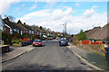
Coombe Rise, Findon Valley
A residential road that links Findon Road, the A24, with Shepherds Mead. The hedgerow of the gardens to the rear of the houses on the left is the old parish boundary between Findon and Broadwater both of which are now part of Worthing whose council developed the suburb once it acquired the land in 1933. Salvington Hill is on the other side of the valley.
Image: © Simon Carey
Taken: 30 Jun 2013
0.18 miles
8
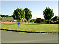
Grassy roundabout across The Heights, Findon Valley
The Heights is the road in the distance with the parked cars, running south from the roundabout. Behind the photographer's back is another stretch of the same road running north.
Image: © Slbs
Taken: 29 Jun 2008
0.19 miles
9
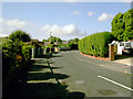
Northernmost stretch of The Heights, Findon Valley
The Heights is a pleasant residential road punctuated by a large roundabout.
Image: © Slbs
Taken: 29 Jun 2008
0.20 miles
10
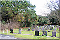
Durrington cemetery, northern edge
In general the older graves are at the northern end of the cemetery.
Image: © Robin Webster
Taken: 26 Feb 2010
0.22 miles