IMAGES TAKEN NEAR TO
Howard Place, BRIGHTON, BN1 3UF
Introduction
This page details the photographs taken nearby to Howard Place, BN1 3UF by members of the Geograph project.
The Geograph project started in 2005 with the aim of publishing, organising and preserving representative images for every square kilometre of Great Britain, Ireland and the Isle of Man.

There are currently over 7.5m images from over14,400 individuals and you can help contribute to the project by visiting https://www.geograph.org.uk
Image Map
Images are licensed for reuse under creativecommons.org/licenses/by-sa/2.0
Notes
- Clicking on the map will re-center to the selected point.
- The higher the marker number, the further away the image location is from the centre of the postcode.
Image Listing (611 Images Found)
Images are licensed for reuse under creativecommons.org/licenses/by-sa/2.0
Image
Details
Distance
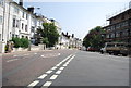
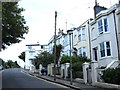
1
Howard Place, Brighton, Sussex
Looking in the opposite direction from Brighton Railway Station. The railway lies to the right of the red brick wall.
Image: © Peter Trimming
Taken: 12 May 2011
0.02 miles
2
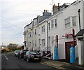
Old Petrol Pumps, Bath Street, Brighton
The old Shellmax pumps date from the 1950s and are believed to belong to one of the earliest petrol stations in Brighton. They continued being used until 2010 when the garage they belonged to closed. The premises was converted into a residence and the pumps kept as decoration and have since been placed on the council's list of historical landmarks. See Image for an image taken in 2006.
Image: © Simon Carey
Taken: 25 Oct 2015
0.02 miles
3
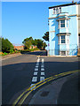
Howard Place
At the junction with Bath Street. Whilst Terminus Road takes you up the hill, Howard Place runs steeply back down it, the wall and fence on the left marking the boundary with the railway. The road was developed between 1848-53 along with others in the area.
Image: © Simon Carey
Taken: 26 Aug 2007
0.03 miles
4
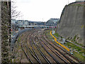
West Coastway line approaches to Brighton Station
Image: © Robin Webster
Taken: 13 Apr 2019
0.03 miles
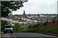
5
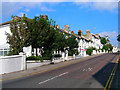
Buckingham Place
The A2010 as it climbs West Hill before dropping down to the station. Developed from the 1840s onwards as a middle class suburb close to the trains. The building with scaffolding further up the hill is St Anne's House, a hostel for the homeless, owned by former boxer Chris Eubank.
Image: © Simon Carey
Taken: 26 Aug 2007
0.03 miles
6
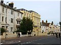
Buckingham Place, Brighton
Part of the A2010 between Seven Dials and Brighton Station that was developed around 1850. Viewed from the junctiuon with Compton Avenue.
Image: © Simon Carey
Taken: 4 Oct 2015
0.03 miles
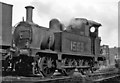
7
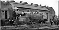
BR Standard 2-6-4T at Brighton Locomotive Depot
BR Standard 4MT 2-6-4T No. 80153 (built 2/57 - the penultimate, withdrawn 3/65) is seen with two standard Diesel 0-6-0 shunters.
Image: © Ben Brooksbank
Taken: 7 Oct 1962
0.04 miles
9
Diminutive 0-6-0T shed-pilot at Brighton Locomotive Depot
Built by Wainwright as the SE&CR P class for work on light branches, they were later used for light 'odd-job' work: No. 31555 was built 6/1910 and withdrawn 2/55. [One of my very early photographs].
Image: © Ben Brooksbank
Taken: 23 Mar 1946
0.04 miles