IMAGES TAKEN NEAR TO
Prestonville Road, BRIGHTON, BN1 3TL
Introduction
This page details the photographs taken nearby to Prestonville Road, BN1 3TL by members of the Geograph project.
The Geograph project started in 2005 with the aim of publishing, organising and preserving representative images for every square kilometre of Great Britain, Ireland and the Isle of Man.

There are currently over 7.5m images from over14,400 individuals and you can help contribute to the project by visiting https://www.geograph.org.uk
Image Map
Images are licensed for reuse under creativecommons.org/licenses/by-sa/2.0
Notes
- Clicking on the map will re-center to the selected point.
- The higher the marker number, the further away the image location is from the centre of the postcode.
Image Listing (264 Images Found)
Images are licensed for reuse under creativecommons.org/licenses/by-sa/2.0
Image
Details
Distance
1
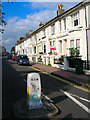
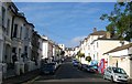
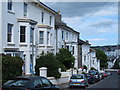
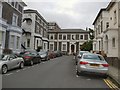
Prestonville Road
Developed in the 1860s by Daniel Friend as part of a middle class suburb called Prestonville. This view looks towards the junction with the A270 with Stanford Road beyond.
Image: © Simon Carey
Taken: 26 Aug 2007
0.01 miles
3
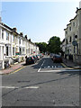
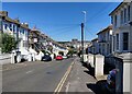
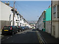
Prestonville Road
A side street linking Old Shoreham Road, which is visible in the foreground, to Seven Dials. Prestonville was the original name of the development in these parts as the land originally lay in the parish of Preston.
Image: © Simon Carey
Taken: 31 Jul 2011
0.02 miles
4
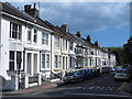
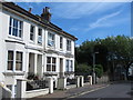
York Villas, Brighton
A residential road running between York Grove and Prestonville Road that was developed in the late 1860s.
Image: © Simon Carey
Taken: 11 Oct 2015
0.03 miles
8
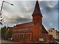
St Luke's church, Prestonville
Built in 1875 in Early English style by John Hill, it has a pleasant red-brick exterior, with a small tower and clock surmounted by a short spire at the south-east corner; it became a parish church in 1878 and the interior was enlarged in 1882 by J.G.Gibbins http://www.mybrightonandhove.org.uk/page_id__8488_path__0p114p456p1612p.aspx
Image: © Paul Gillett
Taken: 28 Jun 2011
0.04 miles
9
Belmont, Brighton
Cul De sac off Dyke Road near the Seven Dials
Image: © Paul Gillett
Taken: 28 Jun 2011
0.04 miles
10
Brighton: Brigden Street
Image is visible as the distinct double line of trees on the far hillside.
Image: © Nigel Cox
Taken: 8 Jun 2008
0.04 miles