IMAGES TAKEN NEAR TO
Regent Hill, BRIGHTON, BN1 3ED
Introduction
This page details the photographs taken nearby to Regent Hill, BN1 3ED by members of the Geograph project.
The Geograph project started in 2005 with the aim of publishing, organising and preserving representative images for every square kilometre of Great Britain, Ireland and the Isle of Man.

There are currently over 7.5m images from over14,400 individuals and you can help contribute to the project by visiting https://www.geograph.org.uk
Image Map
Images are licensed for reuse under creativecommons.org/licenses/by-sa/2.0
Notes
- Clicking on the map will re-center to the selected point.
- The higher the marker number, the further away the image location is from the centre of the postcode.
Image Listing (952 Images Found)
Images are licensed for reuse under creativecommons.org/licenses/by-sa/2.0
Image
Details
Distance
1
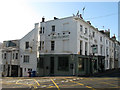
The Florist
Located on the corner of Regent Hill and Upper North Street. I'm pretty certain this used to be known as the Queen Victoria certainly in the 1990s when I spent one or two drunken evenings in here.
Image: © Simon Carey
Taken: 19 Nov 2011
0.02 miles
2
Craft Beer Company, Upper North Street, Brighton
Located on the corner of Regent Hill it was originally the Princess Victoria until the late 2000s when it became The Florist. In 2012 it became the second pub owned by London's Craft Beer Company.
Image: © Simon Carey
Taken: 21 Nov 2015
0.02 miles
3
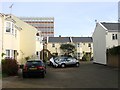
Marlborough Mews, Brighton
A small mews off Marlborough Street that was built in 1987. In the 1870s the site was a malthouse later becoming a furniture factory until its demolition in the 1980s. The office block beyond is Crown House.
Image: © Simon Carey
Taken: 25 Oct 2015
0.02 miles
4
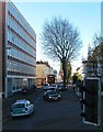
Crown House, Upper North Street, Brighton
Built in the mid 1960s as offices housing the Labour Exchange and a local branch of the HMRC. The latter are still here though the former has moved on and there were plans to turn the top five floors into flats. Viewed from St Nicholas's churchyard with Image in the distance.
Image: © Simon Carey
Taken: 21 Nov 2015
0.03 miles
5
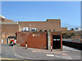
Old Entrance to Regent Row
The western entrance to Image from Regent Hill that was blocked off by the extension of Marks & Spencer during the 1960s.
See http://regencysociety-jamesgray.com/volume26/source/jg_26_246.html for a view taken in 1966.
Image: © Simon Carey
Taken: 31 Jul 2011
0.03 miles
6
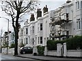
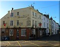
Princess Victoria, Upper North Street
Head north up Marlborough Street then turn east into Upper North Street. The houses on the left were built up from the 1830s onwards. The big block on the right was once the town's major job centre but is now home to the Inland Revenue. The block itself is built on the northern edge of a former chalk pit.
Click on the link to take you to the next page. http://www.geograph.org.uk/photo/212005
Image: © Simon Carey
Taken: 30 Jul 2006
0.03 miles
7
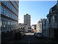
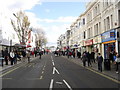
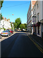
Regent Hill, Brighton
A side street linking Upper North Street to Western Road albeit a busy one as it is used by local buses which terminate outside the Imperial Arcade on Dyke Road as a loop to their starting point on Western Road. Developed in the 1820s though only the western side survives with all of the eastern side removed for the expansion of Marks & Spencer and the construction of Crown House on the immediate left. The large block of flats is Chartwell Court.
Image: © Simon Carey
Taken: 20 Sep 2015
0.03 miles
8
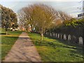
St Nicholas Rest Garden
St Nicholas Rest Garden at the southern end of Dyke Road was laid out in 1840 as an extension cemetery for Brighton's parish church, St Nicholas. It was used for burials until 1853. It is now a city park under the care of the Council and is open to everyone. It provides a green and leafy breathing space not far from the hurly-burly of Western Road. The entrance is through the big stone archway on the opposite side of Dyke Road to the church. http://www.mybrightonandhove.org.uk/category_id__1837_path__0p115p203p.aspx
Image: © Paul Gillett
Taken: 6 Apr 2012
0.04 miles