IMAGES TAKEN NEAR TO
Coldharbour Lane, WORTHING, BN13 3XE
Introduction
This page details the photographs taken nearby to Coldharbour Lane, BN13 3XE by members of the Geograph project.
The Geograph project started in 2005 with the aim of publishing, organising and preserving representative images for every square kilometre of Great Britain, Ireland and the Isle of Man.

There are currently over 7.5m images from over14,400 individuals and you can help contribute to the project by visiting https://www.geograph.org.uk
Image Map (Loading...)


Getting Data...Please wait
Leaflet Map data © OpenStreetMap
Images are licensed for reuse under creativecommons.org/licenses/by-sa/2.0
Notes
- Clicking on the map will re-center to the selected point.
- The higher the marker number, the further away the image location is from the centre of the postcode.
Image Listing (120 Images Found)
Images are licensed for reuse under creativecommons.org/licenses/by-sa/2.0
Image
Details
Distance
1
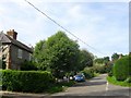
Downsview Cottage, Coldharbour Lane, Patching
On the eastern side of the village and built in the 1960s.
Image: © Simon Carey
Taken: 28 Aug 2017
0.01 miles
2
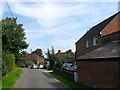
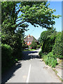
Coldharbour Lane, Patching
This is a view of the Patching end of the lane, close to its junction with Patching Street (which is behind the photographer's back).
Image: © Slbs
Taken: 25 Jun 2008
0.02 miles
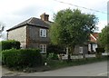
3
3-7, Coldharbour Lane, Patching
Part of a set of seven cottages built in the early 1950s. Numbers 1-2 are out of shot to the right.
Image: © Simon Carey
Taken: 28 Aug 2017
0.04 miles
4
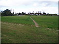
Public Footpath to Cold Harbour Lane
A well defined path to Patching village crosses this field.
Image: © Peter Holmes
Taken: 12 Apr 2008
0.04 miles
5
Dukes Cottage, The Street, Patching
Early 19th century flint cottage overlooking the junction with Coldharbour Lane. May have once been more than one dwelling.
Image: © Simon Carey
Taken: 28 Aug 2017
0.08 miles
7
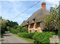
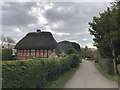
Norfolk Cottage, The Street, Patching
The thatched cottage dates back to at least the 17th century and was once an alehouse.
Image: © Simon Carey
Taken: 28 Aug 2017
0.09 miles
8
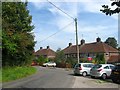
Coldharbour Lane junction with France Lane to the left and The Street
Image: © Dave Spicer
Taken: 20 Dec 2009
0.09 miles
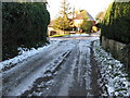
9
Coldharbour Lane
Linking Patching with Longfurlong, the A280 and here looking at its western junction with The Street. The road was known as Deadmans Lane in the 19th century.
Image: © Simon Carey
Taken: 30 May 2009
0.09 miles
10
The Street Patching
On the left is Morella Cottage.
Image: © Chris Thomas-Atkin
Taken: 11 Feb 2019
0.09 miles