IMAGES TAKEN NEAR TO
Titnore Lane, WORTHING, BN13 3UG
Introduction
This page details the photographs taken nearby to Titnore Lane, BN13 3UG by members of the Geograph project.
The Geograph project started in 2005 with the aim of publishing, organising and preserving representative images for every square kilometre of Great Britain, Ireland and the Isle of Man.

There are currently over 7.5m images from over14,400 individuals and you can help contribute to the project by visiting https://www.geograph.org.uk
Image Map
Images are licensed for reuse under creativecommons.org/licenses/by-sa/2.0
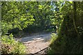
Notes
- Clicking on the map will re-center to the selected point.
- The higher the marker number, the further away the image location is from the centre of the postcode.
Image Listing (24 Images Found)
Images are licensed for reuse under creativecommons.org/licenses/by-sa/2.0
Image
Details
Distance
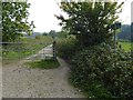
1
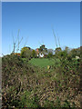
Woodlands
Name of the house viewed from Pot Lane bridleway.
Image: © Simon Carey
Taken: 13 Apr 2009
0.01 miles
3
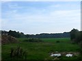
Barn Field
The name of the field according to Ferring's 1837 tithe map that has been merged with Image to the south to form a larger unit. To the west is Pot Lane and to the east is Titnore Wood. Beyond a drive to the north is Potlands Copse.
Image: © Simon Carey
Taken: 28 Aug 2017
0.04 miles
4
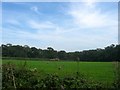
The Four Acres
The name of the field according to Ferring's 1837 tithe map that has been merged with Image to the north to form a larger unit. The field is located to the east of Pot Lane, west of Titnore Wood and north of Highdown Copse.
Image: © Simon Carey
Taken: 28 Aug 2017
0.11 miles
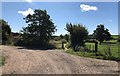
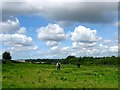
5
Bridleway going south from junction at Potlands Copse
Image: © Shazz
Taken: 3 Oct 2015
0.12 miles
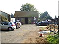
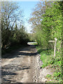
6
Pot Lane
On Pot Lane at the point where it turns left towards Woodlands Stables with the Bridleway heading straight on.
Image: © Chris Thomas-Atkin
Taken: 7 Sep 2018
0.13 miles
7
Pot Lane
The name given to the bridleway that leaves Titnore Road and heads up the northern slope of Highdown Hill.
Image: © Simon Carey
Taken: 13 Apr 2009
0.16 miles
8
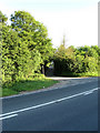
Entrance to Pot Lane
Taken from Titnore Lane. Up until the early 1990s Pot Lane ended on the A27 Arundel Road but was obliterated along with nearby Potlands Farm when the road was widened and a new junction with the A280 built. Titnore Lane itself was then extended eastwards to join the junction.
Image: © Simon Carey
Taken: 30 May 2009
0.16 miles
9
Approaching Pot Lane
On the Bridleway nearing the junction with Pot Lane. Beyond the junction lies Potlands Copse.
Image: © Chris Thomas-Atkin
Taken: 7 Sep 2018
0.16 miles
10
East Field
The name of the field according to Goring's 1839 tithe map part of which has been lost to the construction of the A27/A280 interchange. To the south is Image and to the east is Pot Lane.
Image: © Simon Carey
Taken: 6 Aug 2017
0.19 miles