IMAGES TAKEN NEAR TO
Arundel Road, WORTHING, BN13 3UE
Introduction
This page details the photographs taken nearby to Arundel Road, BN13 3UE by members of the Geograph project.
The Geograph project started in 2005 with the aim of publishing, organising and preserving representative images for every square kilometre of Great Britain, Ireland and the Isle of Man.

There are currently over 7.5m images from over14,400 individuals and you can help contribute to the project by visiting https://www.geograph.org.uk
Image Map (Loading...)


Getting Data...Please wait
Leaflet Map data © OpenStreetMap
Images are licensed for reuse under creativecommons.org/licenses/by-sa/2.0
Notes
- Clicking on the map will re-center to the selected point.
- The higher the marker number, the further away the image location is from the centre of the postcode.
Image Listing (14 Images Found)
Images are licensed for reuse under creativecommons.org/licenses/by-sa/2.0
Image
Details
Distance
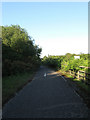
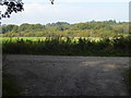
2
Goring Wood
Part of the Castle Goring estate which lies on the eastern side of the wood. Viewed from Titnore Lane.
Image: © Simon Carey
Taken: 30 May 2009
0.09 miles
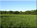
3
Clapham Common
The former common was enclosed in 1812 and is located between the village and the current A27, part is wooded the rest seems to be scrub and waste. This part is near the crossroads of footpaths that run across the common.
Image: © Simon Carey
Taken: 30 May 2009
0.18 miles
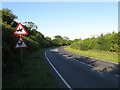
4
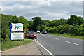
Worthing boundary sign
Somewhat inside the mapped boundary, this sign indicates the local authority border has been crossed. The car is inconveniently parked facing an odd way in an odd place, as there is plenty of pull off room at the viewpoint.
Image: © Robin Webster
Taken: 20 Jun 2010
0.19 miles
5
Remains of the Former A27
Part of the tarmac still in situ serving as a footpath. The single track road was dualled in the early 1990s and much of the former route has disappeared beneath the current trunk road and junction with the A280.
Image: © Simon Carey
Taken: 30 May 2009
0.19 miles
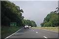
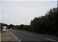
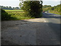
6
Titnore Lane
Marked on some maps as the A2700 but this information has been covered over on all the road signs in the vicinity. Titnore Lane begins at Goring Crossways and headed north to a junction with the A27 Arundel Road beyond the bushes on the curve. When the A27 was widened and a new junction with the A280 built in the early 1990s Titnore Lane was extended westwards to meet the roundabout on the southern side of the A280. The road is a notorious ratrun for those wishing to get in and out of the suburbs of western Worthing.
Image: © Simon Carey
Taken: 30 May 2009
0.19 miles
7
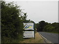
Sign entering Worthing on Titnore Lane
Image: © David Howard
Taken: 23 Jun 2018
0.20 miles
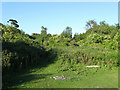
9
Looking across field from track junction in Titnore Wood
Image: © Shazz
Taken: 3 Oct 2015
0.21 miles
10
Junction of track off Titnore Road
The track on the left runs along the edge of Titnore Wood.
Image: © Shazz
Taken: 3 Oct 2015
0.21 miles