IMAGES TAKEN NEAR TO
Cherry Tree Close, WORTHING, BN13 3QJ
Introduction
This page details the photographs taken nearby to Cherry Tree Close, BN13 3QJ by members of the Geograph project.
The Geograph project started in 2005 with the aim of publishing, organising and preserving representative images for every square kilometre of Great Britain, Ireland and the Isle of Man.

There are currently over 7.5m images from over14,400 individuals and you can help contribute to the project by visiting https://www.geograph.org.uk
Image Map (Loading...)


Getting Data...Please wait
Leaflet Map data © OpenStreetMap
Images are licensed for reuse under creativecommons.org/licenses/by-sa/2.0
Notes
- Clicking on the map will re-center to the selected point.
- The higher the marker number, the further away the image location is from the centre of the postcode.
Image Listing (14 Images Found)
Images are licensed for reuse under creativecommons.org/licenses/by-sa/2.0
Image
Details
Distance
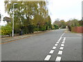
3
Salvington Hill, High Salvington
Viewed from the crossroads with Furze Road and Honeysuckle Lane. The latter along with this road was originally an old coaching route that started at Durrington and crossed the Downs to Storrington and Sullington. The road is now the main access route for the hamlet of High Salvington.
Image: © Simon Carey
Taken: 30 Jun 2013
0.15 miles
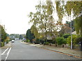
4
The eastern end of West Way at the junction with Salvington Hill
Image: © Shazz
Taken: 1 Nov 2015
0.16 miles
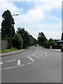
5
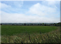
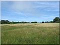
The Old Denshire
The name of the field according to Durrington's 1839 tithe map viewed from the footpath that links Cote to High Salvington. Denshire refers to 'Devenoshiring' an old agricultural practice whereby the topsoil is burnt in order to increase the fertility of a thin soil. Worthing can be seen in the distance.
Image: © Simon Carey
Taken: 30 Jun 2013
0.20 miles
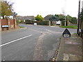
6
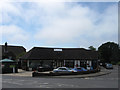
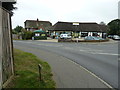
The Village Shop, High Salvington
Located on the corner of Salvington Hill and Furze Road. There are actually two businesses here, the Post Office on the left and a barbers to the right.
Image: © Simon Carey
Taken: 30 Jun 2013
0.21 miles
7
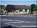
Post Office & Village Shop, Salvington Hill
Image: © Peter Holmes
Taken: 25 Jul 2009
0.21 miles
8
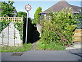
Public footpath 3130
Short cut from Salvington Hill to Furze Road.
Image: © Peter Holmes
Taken: 25 Jul 2009
0.21 miles
9
Village Shop and Barber Shop on Salvington Hill
Image: © Dave Spicer
Taken: 5 Oct 2011
0.21 miles
10
Salvington Hill
The western slope of the hill that now contains the Worthing suburb of High Salvington. Much of this area is now open access and within the boundaries of the new South Downs National Park meaning this popular green space should not be developed in the future.
Image: © Simon Carey
Taken: 30 Jun 2013
0.21 miles