IMAGES TAKEN NEAR TO
Lobelia Drive, WORTHING, BN13 3GL
Introduction
This page details the photographs taken nearby to Lobelia Drive, BN13 3GL by members of the Geograph project.
The Geograph project started in 2005 with the aim of publishing, organising and preserving representative images for every square kilometre of Great Britain, Ireland and the Isle of Man.

There are currently over 7.5m images from over14,400 individuals and you can help contribute to the project by visiting https://www.geograph.org.uk
Image Map
Images are licensed for reuse under creativecommons.org/licenses/by-sa/2.0
Notes
- Clicking on the map will re-center to the selected point.
- The higher the marker number, the further away the image location is from the centre of the postcode.
Image Listing (15 Images Found)
Images are licensed for reuse under creativecommons.org/licenses/by-sa/2.0
Image
Details
Distance
1
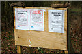
Footpath closure sign, 2010
Someone has ripped off the plan referred to. The area is now built over.
Image: © Robin Webster
Taken: 4 Mar 2010
0.17 miles
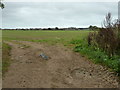
2
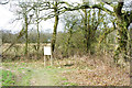
Field corner with footpath, 2010
Now built over. The board advises footpath closure as a prelude to development.
Image: © Robin Webster
Taken: 4 Mar 2010
0.17 miles
3
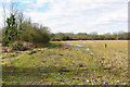
Field edge, West Durrington. 2010
The area is now built up.
Image: © Robin Webster
Taken: 4 Mar 2010
0.19 miles
4
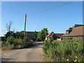
Forest Barn/Forest Barn Mews
A former barn that has now been converted into a residence whilst the grounds to the west have been developed into mock barn conversions. Whilst it retains some rural quality one wonders how long it will be before the creeping westward expansion of Worthing reaches this point.
Image: © Simon Carey
Taken: 20 Jul 2013
0.19 miles
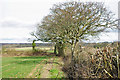
5
Path along field edge, 2010
Now built over. The path has already been blocked further ahead.
Image: © Robin Webster
Taken: 4 Mar 2010
0.20 miles
6
Western Part of Frithes
The name of the field according to Goring's 1840 tithe map that has been expanded to include Image to the east. One wonders how long it will be before the westward creep of Worthing's suburbs engulf this field, the newly constructed West Durrington suburb can be seen in the distance.
Image: © Simon Carey
Taken: 20 Jul 2013
0.21 miles
8
Field corner, West Durrington
The field edge is used as a footpath, although the legal line goes straight across the field.
Image: © Robin Webster
Taken: 4 Mar 2010
0.21 miles
9
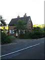
South Lodge, Titnore Lane
The road is very narrow here and there has been recent arguments of bypassing the large in order to upgrade Titnore Lane to A grade status, however, much opposition has meant for the time being the road follows the route with a sensible speed limit.
Image: © Simon Carey
Taken: 30 May 2009
0.22 miles
10
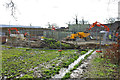
Construction site, West Durrington, 2010
The north-south footpath here was blocked by this, which is where Fulbeck Way was built.
Image: © Robin Webster
Taken: 4 Mar 2010
0.24 miles