IMAGES TAKEN NEAR TO
Celandine Road, WORTHING, BN13 3FW
Introduction
This page details the photographs taken nearby to Celandine Road, BN13 3FW by members of the Geograph project.
The Geograph project started in 2005 with the aim of publishing, organising and preserving representative images for every square kilometre of Great Britain, Ireland and the Isle of Man.

There are currently over 7.5m images from over14,400 individuals and you can help contribute to the project by visiting https://www.geograph.org.uk
Image Map (Loading...)


Getting Data...Please wait
Leaflet Map data © OpenStreetMap
Images are licensed for reuse under creativecommons.org/licenses/by-sa/2.0
Notes
- Clicking on the map will re-center to the selected point.
- The higher the marker number, the further away the image location is from the centre of the postcode.
Image Listing (32 Images Found)
Images are licensed for reuse under creativecommons.org/licenses/by-sa/2.0
Image
Details
Distance
1
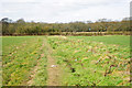
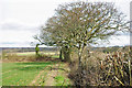
Footpath between fields, West Durrington, 2010
Now a road, Celandine Road.
Image: © Robin Webster
Taken: 4 Mar 2010
0.01 miles
2
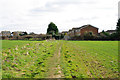
Footpath between fields, West Durrington, 2010
Celandine Road is now built along here.
Image: © Robin Webster
Taken: 4 Mar 2010
0.03 miles
3
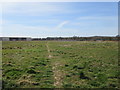
Footpath to Fulbeck Avenue
Public footpath 3114 crossing land soon to be a housing estate.
Image: © Peter Holmes
Taken: 27 Mar 2015
0.03 miles
4
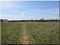
Route to Fulbeck Avenue
Public footpath 3114 crossing land soon to be a housing estate.
Image: © Peter Holmes
Taken: 27 Mar 2015
0.05 miles
5
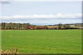
Field corner, West Durrington
The field edge is used as a footpath, although the legal line goes straight across the field.
Image: © Robin Webster
Taken: 4 Mar 2010
0.06 miles
6
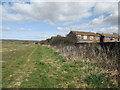
Field, West Durrington, 2010
Looking towards Forest Barn and Forest Mews.
Image: © Robin Webster
Taken: 4 Mar 2010
0.07 miles
7
Footpath adjacent to houses in Brisbane Close
Development land.
Image: © Peter Holmes
Taken: 27 Mar 2015
0.08 miles
8
Footpath to Arundel Road (A27)
Public footpath 3114 crossing land soon to be a housing estate.
Image: © Peter Holmes
Taken: 27 Mar 2015
0.08 miles
9
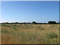
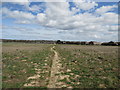
Western Part of Frithes
The name of the field according to Goring's 1840 tithe map that has been expanded to include Image to the east. One wonders how long it will be before the westward creep of Worthing's suburbs engulf this field, the newly constructed West Durrington suburb can be seen in the distance.
Image: © Simon Carey
Taken: 20 Jul 2013
0.09 miles
10
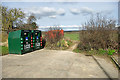
Clothes and shoes
Two recycling bins at the end of Tasman Way.
Image: © Robin Webster
Taken: 4 Mar 2010
0.09 miles