IMAGES TAKEN NEAR TO
Ellis Avenue, WORTHING, BN13 3DY
Introduction
This page details the photographs taken nearby to Ellis Avenue, BN13 3DY by members of the Geograph project.
The Geograph project started in 2005 with the aim of publishing, organising and preserving representative images for every square kilometre of Great Britain, Ireland and the Isle of Man.

There are currently over 7.5m images from over14,400 individuals and you can help contribute to the project by visiting https://www.geograph.org.uk
Image Map (Loading...)


Getting Data...Please wait
Leaflet Map data © OpenStreetMap
Images are licensed for reuse under creativecommons.org/licenses/by-sa/2.0
Notes
- Clicking on the map will re-center to the selected point.
- The higher the marker number, the further away the image location is from the centre of the postcode.
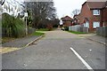
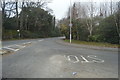
Image Listing (12 Images Found)
Images are licensed for reuse under creativecommons.org/licenses/by-sa/2.0
Image
Details
Distance
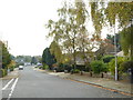
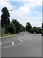
1
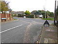
The eastern end of West Way at the junction with Salvington Hill
Image: © Shazz
Taken: 1 Nov 2015
0.09 miles

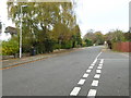
10
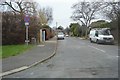
Salvington Hill, High Salvington
Viewed from the crossroads with Furze Road and Honeysuckle Lane. The latter along with this road was originally an old coaching route that started at Durrington and crossed the Downs to Storrington and Sullington. The road is now the main access route for the hamlet of High Salvington.
Image: © Simon Carey
Taken: 30 Jun 2013
0.22 miles