IMAGES TAKEN NEAR TO
Russell Square, BRIGHTON, BN1 2EE
Introduction
This page details the photographs taken nearby to Russell Square, BN1 2EE by members of the Geograph project.
The Geograph project started in 2005 with the aim of publishing, organising and preserving representative images for every square kilometre of Great Britain, Ireland and the Isle of Man.

There are currently over 7.5m images from over14,400 individuals and you can help contribute to the project by visiting https://www.geograph.org.uk
Image Map
Images are licensed for reuse under creativecommons.org/licenses/by-sa/2.0
Notes
- Clicking on the map will re-center to the selected point.
- The higher the marker number, the further away the image location is from the centre of the postcode.
Image Listing (1251 Images Found)
Images are licensed for reuse under creativecommons.org/licenses/by-sa/2.0
Image
Details
Distance
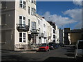
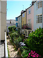
1
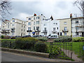
Russell Square, Brighton
A view of the north side, which lacks the uniformity of the south side.
Image: © Robin Webster
Taken: 13 Apr 2019
0.01 miles
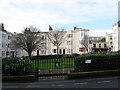
2
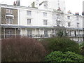
Russell Square, Brighton
Properties along southern side of square.
Image: © Rib
Taken: 18 Jan 2010
0.02 miles
3
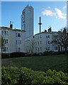
Brighton: across Clarence Square at dusk
The British Airways i360 - which no doubt gave striking views on this bright but chilly April evening - is to the right of the Sussex Heights tower block.
Image: © John Sutton
Taken: 7 Apr 2022
0.02 miles
4
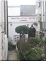
Brighton Little Theatre
Located at Clarence Gardens, Brighton http://www.the-little.co.uk/
Image: © Rib
Taken: 18 Jan 2010
0.02 miles
6
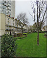
Brighton: Russell Square
Regency terraces of 1820 dwarfed by a tower block.
Image: © John Sutton
Taken: 8 Apr 2022
0.02 miles
7
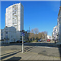
Brighton: Russell Square contrast
A modest Regency square of 1820, dominated by the Sussex Heights tower block.
Image: © John Sutton
Taken: 9 Apr 2022
0.02 miles
8
Clarence Square
Lying to the immediate south of Western Road and to the west of Churchill Square this small square was built around the 1820s The open area of the square was originally private but has been opened to the public since 1884.
Image: © Simon Carey
Taken: 25 Jan 2014
0.03 miles
9
Clarence Gardens
Head east along Western Road and turn south into Clarence Square; as the road turns east Clarence Gardens occupies a small corner. Clarence Square was an early development from the 1800s onwards and was largely competed by the 1820s. At the end of this row is a small hall originally built as a chapel in 1830. Since then it has been an infants school (1852), Mission Hall (1884), an Art School (1899) and from 1940 onwards been home to the Little Theatre Company - Little as the capacity is only 80, making it the smallest theatre in Brighton.
Click on the link to take you to the next page. http://www.geograph.org.uk/photo/211921
Image: © Simon Carey
Taken: 30 Jul 2006
0.03 miles
10
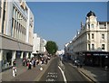
Brighton: Western Road
Approaching the junction with the road that leads down to Clarence Square on the right, in front of Coffee Republic, and with the road, Marlborough Street, at the end of the department store building on the left. The eastbound carriageway here is for buses and cycles only.
Image: © Nigel Cox
Taken: 8 Jun 2008
0.03 miles