IMAGES TAKEN NEAR TO
Ancren Close, WORTHING, BN12 6PD
Introduction
This page details the photographs taken nearby to Ancren Close, BN12 6PD by members of the Geograph project.
The Geograph project started in 2005 with the aim of publishing, organising and preserving representative images for every square kilometre of Great Britain, Ireland and the Isle of Man.

There are currently over 7.5m images from over14,400 individuals and you can help contribute to the project by visiting https://www.geograph.org.uk
Image Map
Images are licensed for reuse under creativecommons.org/licenses/by-sa/2.0
Notes
- Clicking on the map will re-center to the selected point.
- The higher the marker number, the further away the image location is from the centre of the postcode.
Image Listing (42 Images Found)
Images are licensed for reuse under creativecommons.org/licenses/by-sa/2.0
Image
Details
Distance
1
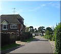
Ancren Close, Ferring
A cul de sac off littlehampton Road that was built in the 1960s on the site of a former house called Ancrens Rest. Once a field called Miller's Croft according to Ferring's 1837 tithe map
Image: © Simon Carey
Taken: 6 Aug 2017
0.02 miles
2
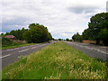
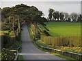
Littlehampton Road
The main A259 that runs along the northern edge of the village linking Worthing to Littlehampton.
Image: © Simon Carey
Taken: 20 Jul 2008
0.04 miles
3
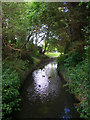
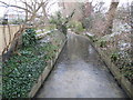
Ferring Rife
Rife is a local name for a stream common in the coastal plain between Ferring and Pagham Harbour. Taken from the footbridge that carries the path from Downview Avenue to Littlehampton Road, this part of the stream has been straightened in order to pass through the houses many of whose gardens back onto it.
Image: © Simon Carey
Taken: 20 Jul 2008
0.06 miles
4
Littlehampton Road, Ferring
The A259 provides the northern boundary of the settlement of Ferring.
Image: © Simon Carey
Taken: 6 Aug 2017
0.06 miles
5
Footbridge over Ferring Rife
Opposite view to Image, taking the footpath from the A259 Littlehampton Road over the stream and onto Downview Avenue.
Image: © Simon Carey
Taken: 20 Jul 2008
0.07 miles
6
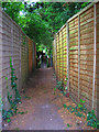
Footpath to Littlehampton Road
Linking Downview Avenue with the A259. Beyond the fences is the footbridge over Ferring Rife.
Image: © Simon Carey
Taken: 20 Jul 2008
0.07 miles
7
Road to Highdown Hotel
A beautiful approach to the hotel and viewpoint. The road is also the approach to the renowned Highdown Gardens, created by Sir Frederick Stern O.B.E. and his wife Lady Stern, from a chalk pit nearly 100years ago.
This view is situated in the upper section of the grid square fairly east of the centre. It was taken looking north
Image: © Pam Brophy
Taken: 15 Apr 2005
0.07 miles
8

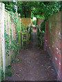
Twitten to Littlehampton Road (A259)
Public footpath 2122 from Ferring Lane.
Image: © Peter Holmes
Taken: 31 Jan 2015
0.07 miles
9
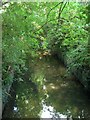
Ferring Rife
A small waterway that rises in Durrington and enters the sea via an outfall on the south western edge of Ferring parish. Rife is a local Sussex dialect word for a small river and the name is particularly numerous on the coastal plain between Worthing and Chichester. Ferring Rife is the eastern most example.
Image: © Simon Carey
Taken: 6 Aug 2017
0.07 miles
10
Ferring Rife flowing seawards
Looks peaceful now but a combination of rain, blocked culverts and high tides caused substantial flooding in 1980/81.
Image: © Peter Holmes
Taken: 31 Jan 2015
0.07 miles