IMAGES TAKEN NEAR TO
The Avenue, WORTHING, BN12 6HH
Introduction
This page details the photographs taken nearby to The Avenue, BN12 6HH by members of the Geograph project.
The Geograph project started in 2005 with the aim of publishing, organising and preserving representative images for every square kilometre of Great Britain, Ireland and the Isle of Man.

There are currently over 7.5m images from over14,400 individuals and you can help contribute to the project by visiting https://www.geograph.org.uk
Image Map
Images are licensed for reuse under creativecommons.org/licenses/by-sa/2.0
Notes
- Clicking on the map will re-center to the selected point.
- The higher the marker number, the further away the image location is from the centre of the postcode.
Image Listing (20 Images Found)
Images are licensed for reuse under creativecommons.org/licenses/by-sa/2.0
Image
Details
Distance
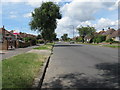
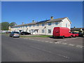
1
Durrington Housing, Maybridge Crescent
Typical Durrington housing just north of the railway near The Strand.
Image: © Chris Shaw
Taken: 17 Jun 2005
0.04 miles
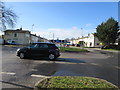
3
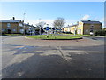
Traffic calming roundabout
In The Strand at junction with Maybridge Crescent (to the north) and The Quadrant (to the South).
Image: © Peter Holmes
Taken: 23 Feb 2015
0.11 miles
4
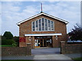
Maybridge Parish Church
Maybridge St Richard, Church of England Parish Church is situated in Collingwood Road a residential area of Goring-by-Sea.
Image: © Peter Holmes
Taken: 15 Oct 2007
0.12 miles
5
Traffic calming roundabout
In The Strand at junction with Maybridge Crescent (to the north) and The Quadrant (to the South).
Image: © Peter Holmes
Taken: 23 Feb 2015
0.13 miles
6
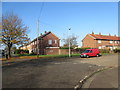
The Strand at junction with Grenville Avenue
Edge of the Maybridge Estate.
Image: © Peter Holmes
Taken: 2 Nov 2015
0.14 miles
7
Solar Power
The Strand at junction with Alexandra Court.
Image: © Peter Holmes
Taken: 27 Apr 2015
0.16 miles
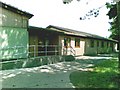
8
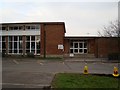
Field Place First School
First school for students aged 4 to 8. Originally known as John Selden Infants School (later First School), was renamed in the mid-1990s. Building dates from 1954.
Image: © WorthingMan
Taken: 15 Feb 2009
0.17 miles
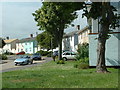
9
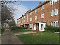
Terraced maisonettes
Limbrick Lane BN12 6AE.
Image: © Peter Holmes
Taken: 16 Apr 2015
0.17 miles