IMAGES TAKEN NEAR TO
Kilham Way, WORTHING, BN12 6FJ
Introduction
This page details the photographs taken nearby to Kilham Way, BN12 6FJ by members of the Geograph project.
The Geograph project started in 2005 with the aim of publishing, organising and preserving representative images for every square kilometre of Great Britain, Ireland and the Isle of Man.

There are currently over 7.5m images from over14,400 individuals and you can help contribute to the project by visiting https://www.geograph.org.uk
Image Map
Images are licensed for reuse under creativecommons.org/licenses/by-sa/2.0
Notes
- Clicking on the map will re-center to the selected point.
- The higher the marker number, the further away the image location is from the centre of the postcode.
Image Listing (44 Images Found)
Images are licensed for reuse under creativecommons.org/licenses/by-sa/2.0
Image
Details
Distance
1
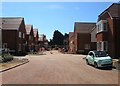
Kilham Way, Ferring
New development started in 2017 and scheduled to be completed in 2018. Originally a field called The Eight Acres according to Ferring's 1837 tithe map.
Image: © Simon Carey
Taken: 6 Aug 2017
0.01 miles
2
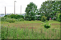
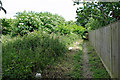
Overgrown field by A259
The main road is beyond.
Image: © Robin Webster
Taken: 20 Jun 2010
0.01 miles
3
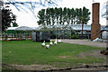
Geese at Ferring Nurseries
No lawn mowing needed here! Viewed from the adjacent public footpath.
Image: © Robin Webster
Taken: 20 Jun 2010
0.05 miles
4
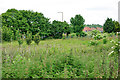
Overgrown field by A259
The main road is beyond.
Image: © Robin Webster
Taken: 20 Jun 2010
0.05 miles
5
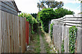
Footpath 2125, Ferring
The path starts to be hemmed in by back gardens as it heads towards Langbury Lane.
Image: © Robin Webster
Taken: 20 Jun 2010
0.05 miles
6
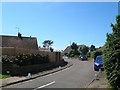
Langbury Close, Ferring
A cul de sac of bungalows off Langbury Lane that was built in the 1950s. Once a small field called Garratts Land according to Ferring's 1837 tithe map.
Image: © Simon Carey
Taken: 6 Aug 2017
0.06 miles
7
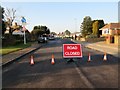
Langbury Lane closed at junction with A259
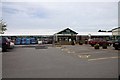
Road closed for 24 hours due to dangerous gas leak at near Asda store, causing serious disruption to traffic on Littlehamption Road (A259).
Image: © Peter Holmes
Taken: 22 Jan 2017
0.06 miles
8
Footpath 2125, Ferring
Heading out of town, but not free of back gardens yet.
Image: © Robin Webster
Taken: 20 Jun 2010
0.07 miles
10
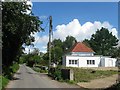
White Cottage, Hangleton Lane, Hangleton, Ferring
Located at the southern end of the lane and appears to have been built in the post war period.
Image: © Simon Carey
Taken: 6 Aug 2017
0.10 miles