IMAGES TAKEN NEAR TO
Sea Drive, WORTHING, BN12 5SS
Introduction
This page details the photographs taken nearby to Sea Drive, BN12 5SS by members of the Geograph project.
The Geograph project started in 2005 with the aim of publishing, organising and preserving representative images for every square kilometre of Great Britain, Ireland and the Isle of Man.

There are currently over 7.5m images from over14,400 individuals and you can help contribute to the project by visiting https://www.geograph.org.uk
Image Map
Images are licensed for reuse under creativecommons.org/licenses/by-sa/2.0
Notes
- Clicking on the map will re-center to the selected point.
- The higher the marker number, the further away the image location is from the centre of the postcode.
Image Listing (29 Images Found)
Images are licensed for reuse under creativecommons.org/licenses/by-sa/2.0
Image
Details
Distance
1
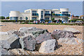
Blue Waters
Block of 9 flats on Sea Drive completed in 2009, replacing a mid 20th Century house named Lane End.
Image: © Ian Capper
Taken: 21 Sep 2021
0.01 miles
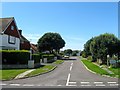
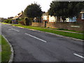
2
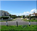
Sea Drive, Ferring
A cul de sac off Sea Lane developed in the mid 1950s on the site of a former field called The Twelve Acres according to Ferring's 1837 tithe map.
Image: © Simon Carey
Taken: 6 Aug 2017
0.04 miles
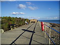
3
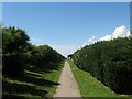
Pattersons Walk, Ferring
A public footpath linking Sea Lane to the western end of Ferring running alongside the beach to the south and houses to the north. There is no roadway alongside the beach in the village.
Image: © Simon Carey
Taken: 6 Aug 2017
0.04 miles
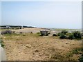
4
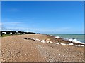
Goring Gap Beach
The section of beach that lies between Ferring and Goring, the latter located beyond the trees in the distance.
Image: © Simon Carey
Taken: 6 Aug 2017
0.05 miles
5
St Malo Close, Ferring
A cul de sac off Sea lane that was developed in the late 1950s.
Image: © Simon Carey
Taken: 6 Aug 2017
0.07 miles
6
Type 26 Pillbox
Situated south of Pattersons Walk, Ferring this pillbox was built in 1941 as part of a network of defences to prevent an anticipated invasion during the second world war.
Image: © Peter Holmes
Taken: 28 Oct 2007
0.08 miles
7
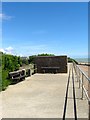
Type 26 Pillbox, Ferring
The only surviving element of the Second World War beach defences has been built into the sea wall, bricked up and rendered with only the plaque on the side to inform people what the structure once was.
Image: © Simon Carey
Taken: 6 Aug 2017
0.08 miles
10
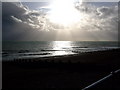
Ferring Beach
Mid afternoon with a moody looking sky which was a prelude to heavy rain
Image: © mike lis
Taken: 4 Nov 2009
0.09 miles