IMAGES TAKEN NEAR TO
Onslow Drive, WORTHING, BN12 5RX
Introduction
This page details the photographs taken nearby to Onslow Drive, BN12 5RX by members of the Geograph project.
The Geograph project started in 2005 with the aim of publishing, organising and preserving representative images for every square kilometre of Great Britain, Ireland and the Isle of Man.

There are currently over 7.5m images from over14,400 individuals and you can help contribute to the project by visiting https://www.geograph.org.uk
Image Map
Images are licensed for reuse under creativecommons.org/licenses/by-sa/2.0
Notes
- Clicking on the map will re-center to the selected point.
- The higher the marker number, the further away the image location is from the centre of the postcode.
Image Listing (107 Images Found)
Images are licensed for reuse under creativecommons.org/licenses/by-sa/2.0
Image
Details
Distance
1
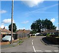
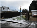
West Onslow Close, Ferring
A cul de sac off Onslow Drive that was developed in the mid 1950s.
Image: © Simon Carey
Taken: 6 Aug 2017
0.02 miles
2
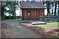
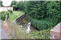
Pump house, Ferring
In a small compound surrounded by trees just south of the railway.
Image: © Robin Webster
Taken: 20 Jun 2010
0.03 miles
3
Footpath 2113, Ferring
Just south of the level crossing of the railway.
Image: © Robin Webster
Taken: 20 Jun 2010
0.04 miles
4
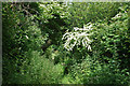
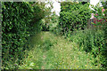
Footpath 2114/1, Ferring
A less popular section of the path, running between the back gardens of houses on Meadow Way to the right and Onslow Caravan Park to the left. An easier but less green route is to use Meadow Way.
Image: © Robin Webster
Taken: 20 Jun 2010
0.04 miles
5
Footpath to Onslow Drive
Public footpath 2113 from route 700 bus stop in Langbury Lane.
Image: © Peter Holmes
Taken: 31 Jan 2015
0.05 miles
6
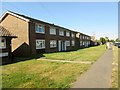
Flats, Onslow Drive, BN12 5RS
Double block of 4 flats.
Image: © Peter Holmes
Taken: 24 Aug 2016
0.06 miles
7
Footpath 2114/1, Ferring
A less popular section of the path, running between the back gardens of houses on Meadow Way to the right and Onslow Caravan Park to the left. An easier but less green route is to use Meadow Way.
Image: © Robin Webster
Taken: 20 Jun 2010
0.07 miles
8
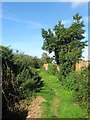
Public Footpath 2114, Ferring
Linking Meadow Way to the Ferring Country Centre. Beyond the fence to the right is Onslow Caravan Park.
Image: © Simon Carey
Taken: 6 Aug 2017
0.07 miles
9
Ferring Rife at Langbury Lane
The rife has very clear water, as most chalk streams do, but this one has to make a passage through several potential sources of pollution.
Image: © Robin Webster
Taken: 20 Jun 2010
0.07 miles
10
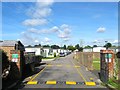
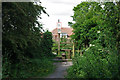
Onslow Caravan Park, Ferring
Located at the end of Onslow Drive and dating from the 1960s. Once a field called Clappers Meadow according to Ferring's 1837 tithe map.
Image: © Simon Carey
Taken: 6 Aug 2017
0.07 miles