IMAGES TAKEN NEAR TO
The Strand, WORTHING, BN12 5QX
Introduction
This page details the photographs taken nearby to The Strand, BN12 5QX by members of the Geograph project.
The Geograph project started in 2005 with the aim of publishing, organising and preserving representative images for every square kilometre of Great Britain, Ireland and the Isle of Man.

There are currently over 7.5m images from over14,400 individuals and you can help contribute to the project by visiting https://www.geograph.org.uk
Image Map
Images are licensed for reuse under creativecommons.org/licenses/by-sa/2.0
Notes
- Clicking on the map will re-center to the selected point.
- The higher the marker number, the further away the image location is from the centre of the postcode.
Image Listing (49 Images Found)
Images are licensed for reuse under creativecommons.org/licenses/by-sa/2.0
Image
Details
Distance
1
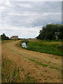
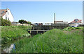
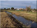
Ferring Rife
Rife is the local name given to a stream in the coastal plain between Ferring and Pagham Harbour. This view looks down the well embanked watercourse towards its sluice just north of the Blue Bird Cafe.
Image: © Simon Carey
Taken: 20 Jul 2008
0.02 miles
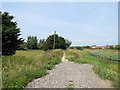
3
Beach Car Park, Ferring
This section was marked as sea beach on Ferring's 1837 tithe map. Now the main car park for Ferring Beach and the Bluebird Cafe and can get very busy during the day. The previous day's rain has left large puddles in the middle section.
Image: © Simon Carey
Taken: 6 Aug 2017
0.04 miles
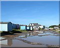
4
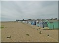
Beach Huts, Ferring Beach
Located next to the Bluebird Cafe and squeezed between the car park and the beach.
Image: © Simon Carey
Taken: 17 Sep 2017
0.04 miles
5
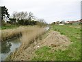
Ferring Rife outfall sluice
The Rife passes through the shingle beach via this sluice. Weed screens are in front of the sluice itself, and to the right of the sluice (mostly hidden) is a good lorry-load of recently extracted weed. To the right is the Bluebird Cafe overlooking the beach. The east bank of the Rife is a public footpath, the west is not, but freely used as such.
Image: © Robin Webster
Taken: 29 May 2007
0.04 miles
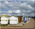
6
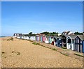
Ferring, beach huts
Overlooking Ferring Beach.
Image: © Mike Faherty
Taken: 9 Mar 2019
0.04 miles
7
Ferring Rife
Drainage ditch flowing from the South Downs and draining into the Channel just to the South.
Image: © Mike Faherty
Taken: 9 Mar 2019
0.04 miles
8
Beach Huts, Ferring
Image: © Simon Carey
Taken: 6 Aug 2017
0.04 miles
9
The Rife Ferring
Looking towards Highdown Hill to the north and to the south down to the sea.
Image: © anni stevens
Taken: 25 Nov 2005
0.05 miles
10
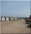
Beach Huts at Ferring
Near to the Bluebird cafe
Image: © Paul Gillett
Taken: 16 Jul 2013
0.05 miles