IMAGES TAKEN NEAR TO
Ferringham Way, WORTHING, BN12 5NG
Introduction
This page details the photographs taken nearby to Ferringham Way, BN12 5NG by members of the Geograph project.
The Geograph project started in 2005 with the aim of publishing, organising and preserving representative images for every square kilometre of Great Britain, Ireland and the Isle of Man.

There are currently over 7.5m images from over14,400 individuals and you can help contribute to the project by visiting https://www.geograph.org.uk
Image Map
Images are licensed for reuse under creativecommons.org/licenses/by-sa/2.0
Notes
- Clicking on the map will re-center to the selected point.
- The higher the marker number, the further away the image location is from the centre of the postcode.
Image Listing (48 Images Found)
Images are licensed for reuse under creativecommons.org/licenses/by-sa/2.0
Image
Details
Distance
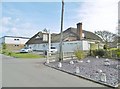
1
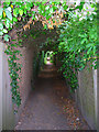
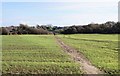
Footpath to Ferringham Lane
Linking Ferring Rife with Ferringham Lane and a virtual tunnel at this point, the light on the foliage in the foreground is actually from the flash on my camera not the sun.
Image: © Simon Carey
Taken: 20 Jul 2008
0.03 miles
2
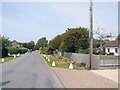
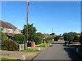
West Drive, Ferring
Quiet street leading from the seafront
Image: © Paul Gillett
Taken: 16 Jul 2013
0.05 miles
3
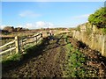
Footpath adjacent to Ferring Rife
Public footpath 2142.
Image: © Peter Holmes
Taken: 28 Jan 2017
0.06 miles
4
Tudor Close, Ferringham Lane
A public house and restaurant in southern Ferring. Originally constructed as a barn and cow sheds in the early 18th century it was converted into residence in the early 20th. It later became the Tudor Close Prep School for Boys, served as an officers mess for the Canadian Army before becoming a pub in 1947. Beyond it is a small row of shops in Ocean Parade.
Image: © Simon Carey
Taken: 20 Jul 2008
0.09 miles
5
Ferring, Tudor Close
Public house on Ferringham Lane. The building is partially cobble-clad, and is shown on old OS maps; presumably a former barn. Internally, side entrance with one large room, with wooden beams, exposed cobble walls, gallery and side wall. Back counter, drinking and eating areas front. TV, patio. Cask ales on offer: Arundel Castle, Harvey's Sussex Bitter, Sharp's Doom Bar.
Image: © Mike Faherty
Taken: 9 Mar 2019
0.09 miles
6
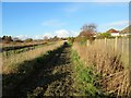
Footpath adjacent to Ferring Rife
Public footpath 2142.
Image: © Peter Holmes
Taken: 28 Jan 2017
0.11 miles
7
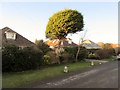
Conifer in Upper West Drive, BN12 5RG
Residential bungalows.
Image: © Peter Holmes
Taken: 28 Jan 2017
0.12 miles
8
Pump House, Oval Waye, Ferring
Ferring Rife runs behind these houses and is prone to flooding.
Image: © Simon Carey
Taken: 6 Aug 2017
0.12 miles
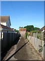
9
Path towards Ferring Rife
Not marked on maps but clearly frequently used by local folk.
Image: © Fernweh
Taken: 1 Nov 2014
0.12 miles
10
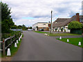
Oval Waye, Ferring
A residential road that runs in a crescent to the west of West Drive. It was developed from the mid 1920s onwards.
Image: © Simon Carey
Taken: 6 Aug 2017
0.12 miles