IMAGES TAKEN NEAR TO
Bartholomew Square, BRIGHTON, BN1 1JA
Introduction
This page details the photographs taken nearby to Bartholomew Square, BN1 1JA by members of the Geograph project.
The Geograph project started in 2005 with the aim of publishing, organising and preserving representative images for every square kilometre of Great Britain, Ireland and the Isle of Man.

There are currently over 7.5m images from over14,400 individuals and you can help contribute to the project by visiting https://www.geograph.org.uk
Image Map
Images are licensed for reuse under creativecommons.org/licenses/by-sa/2.0
Notes
- Clicking on the map will re-center to the selected point.
- The higher the marker number, the further away the image location is from the centre of the postcode.
Image Listing (1881 Images Found)
Images are licensed for reuse under creativecommons.org/licenses/by-sa/2.0
Image
Details
Distance
1
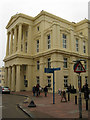
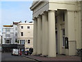
Brighton Town Hall
Constructed between 1830-32 on the site of a former market. Prior to that it had once been the site of the former Priory of St Bartholomews which was burnt down in the early 16th by a French raid which incinerated much of the rest of the old town. This is the northern entrance on Bartholomews.
Image: © Simon Carey
Taken: 30 Oct 2011
0.00 miles
3
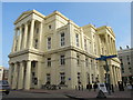
Brighton Town Hall, Bartholomews / Bartholomew Square, BN1
Image: © Mike Quinn
Taken: 8 May 2012
0.01 miles
4
Sussex Tavern, East Street
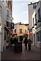
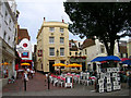
Head east down Prince Albert Street and Bartholomews then head north up East Street. East Street was built up from the 14th century onwards and rapidly developed into a shopping area from the early 19th century. This small square in East Street may have been a fishermans area until quite late enabling it today to have the feel of a small continental town. The Sussex Tavern was opened in the late 18th century and was originally called the Spread Eagle. The rest of the square is made up of three restaurants whose tables are in view. The freeholders of the white building partially obscured by a tree kicked up a stink this year about the tables claiming the tables prevented them from letting the shop. The Council forced the two restaurants to leave a gap to the empty shop which they duly did only to discover the new leaseholders were Pret a Porter who promptly filled the gap with their new tables. Perhaps that waft of fish isn't just from the oyster bar on the left hand side.
Click on the link to take you to the next page. http://www.geograph.org.uk/photo/230727
Image: © Simon Carey
Taken: 1 Sep 2006
0.01 miles
5
A Crisp Sunny Morning - East Street Brighton
Not much more to say beyond the title. East Street is one of Brighton's central shopping streets. Visitors might like to be aware that as well as East Street there is also a North Street and a West Street.
Image: © mysteron
Taken: 13 Jan 2005
0.01 miles
6
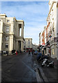
Town Hall, Bartholomews
The road derives its name from the priory that once stood on the site of the Town Hall, it was burnt down, along with the rest of the town, by the French in 1515. For a while the local market was held on the spot until the current building was erected in 1830-32.
Image: © Simon Carey
Taken: 11 Jan 2009
0.01 miles
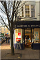
7
Regent Arcade, Brighton
Opened in 1963 on the site of Warden's Buildings. There are access points in Bartholomews, Market Street and East Street. Another was extended north to Market Street but was closed a while ago and is now occupied by a small shop.
Image: © Simon Carey
Taken: 27 Oct 2017
0.01 miles
8
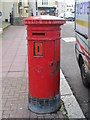
Victorian postbox, Bartholomews, BN1
Image: © Mike Quinn
Taken: 8 May 2012
0.01 miles
9
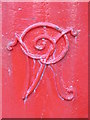
Victorian postbox, Bartholomews, BN1 - royal cipher
See Image
Image: © Mike Quinn
Taken: 8 May 2012
0.01 miles