IMAGES TAKEN NEAR TO
South Coast Road, PEACEHAVEN, BN10 7JE
Introduction
This page details the photographs taken nearby to South Coast Road, BN10 7JE by members of the Geograph project.
The Geograph project started in 2005 with the aim of publishing, organising and preserving representative images for every square kilometre of Great Britain, Ireland and the Isle of Man.

There are currently over 7.5m images from over14,400 individuals and you can help contribute to the project by visiting https://www.geograph.org.uk
Image Map
Images are licensed for reuse under creativecommons.org/licenses/by-sa/2.0
Notes
- Clicking on the map will re-center to the selected point.
- The higher the marker number, the further away the image location is from the centre of the postcode.
Image Listing (81 Images Found)
Images are licensed for reuse under creativecommons.org/licenses/by-sa/2.0
Image
Details
Distance
1
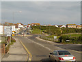
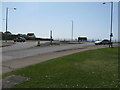
Peacehaven, South Coast Road
Approaching Peacehaven via the A259, South Coast Road.
Image: © David Dixon
Taken: 5 Aug 2012
0.03 miles
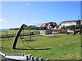
2
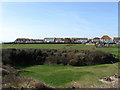
The Dell
A small dip in the landscape has been given over as a public park. The dip in the foreground is the remains of a former gravel pit whilst the houses in the distance are in the southern section of Rowe Avenue.
Image: © Simon Carey
Taken: 15 Mar 2009
0.04 miles
6
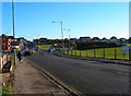
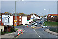
South Coast Road, Peacehaven
Originally known as Dover Road and is the main A259 road through the town. Other than Hoddern Farm and two coastguard cottages in Telscombe Cliffs the only thing one would have found in this square from the 19th century. The dip in the park on the right hand side is not actually a natural feature but comes courtesy of the Luftwaffe. This view looks east toward the roundabout.
Image: © Simon Carey
Taken: 25 Dec 2005
0.06 miles
7
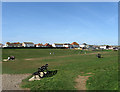
The Dell
A dip in the downs has led to this space being given over as a public park. The houses in the distance are on the southern section of Rowe Avenue whilst the playground to the right has only recently been opened having originally been located in the former gravel pit.
Image: © Simon Carey
Taken: 15 Mar 2009
0.06 miles
8
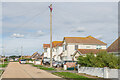
Hoddern Avenue
Residential road in Peacehaven.
Image: © Ian Capper
Taken: 20 Sep 2022
0.07 miles
9
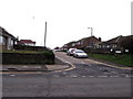
Sutton Avenue junction with the A259
On the far side of the roundabout is a recreation ground.
Image: © Dave Spicer
Taken: 23 Apr 2013
0.07 miles
10
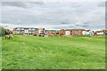
The Dell
Recreation ground in Peacehaven off the A259 South Coast Road (in the background).
Image: © Ian Capper
Taken: 20 Sep 2022
0.07 miles