IMAGES TAKEN NEAR TO
Britain Street, BURY, BL9 9PB
Introduction
This page details the photographs taken nearby to Britain Street, BL9 9PB by members of the Geograph project.
The Geograph project started in 2005 with the aim of publishing, organising and preserving representative images for every square kilometre of Great Britain, Ireland and the Isle of Man.

There are currently over 7.5m images from over14,400 individuals and you can help contribute to the project by visiting https://www.geograph.org.uk
Image Map
Images are licensed for reuse under creativecommons.org/licenses/by-sa/2.0
Notes
- Clicking on the map will re-center to the selected point.
- The higher the marker number, the further away the image location is from the centre of the postcode.
Image Listing (29 Images Found)
Images are licensed for reuse under creativecommons.org/licenses/by-sa/2.0
Image
Details
Distance
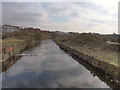
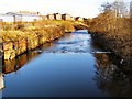
3
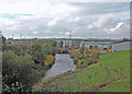
River Irwell
Looking upstream with Hardy's Gate Bridge in the centre of the picture. Downstream of this point the river rounds a meander before joining the River Roch near Blackford Bridge.
Image: © Dennis Turner
Taken: 28 Oct 2005
0.09 miles
4
River Irwell
Looking down stream from the A6053 as it crosses the river
Image: © Alexander P Kapp
Taken: 18 Jul 2007
0.10 miles
6
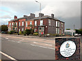
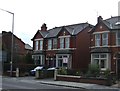
Birthplace of an author
The corner property in the Mount Sion district of Bury is the birthplace of Richmal Crompton. The house was built in the late 19th century at the junction of Hampson Mill Road and Manchester Road. Hampson Mill was a textile print works close to the River Roch and adjoining the mill was Hampson Flour Mill.
Image: © Dennis Turner
Taken: 28 Oct 2005
0.12 miles
7
River Irwell, Radcliffe
Looking downstream from Hardy's Gate Bridge. The land on the right hand side (west bank) of the river has been cleared ready for development as the "Bury South Business Park".
Image: © David Dixon
Taken: 13 Mar 2012
0.14 miles
8
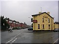
The Bridge
Public House on Dumers Lane (pronounced locally as "Jewmers"), Bury at the junction of York Street. SD803084.
Image: © Keith Williamson
Taken: 12 Oct 2005
0.14 miles
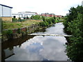
9
River Irwell
Looking downstream from Dumers Lane.
Image: © David Dixon
Taken: 31 Jan 2010
0.15 miles
10
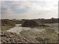
Site For The Bury South Business Park
This land off Dumers Lane, next to the River Irwell, has been cleared in preparation of the building of the Bury South Business Park.
Image: © David Dixon
Taken: 13 Mar 2012
0.17 miles