IMAGES TAKEN NEAR TO
Rydal Close, BURY, BL9 9LL
Introduction
This page details the photographs taken nearby to Rydal Close, BL9 9LL by members of the Geograph project.
The Geograph project started in 2005 with the aim of publishing, organising and preserving representative images for every square kilometre of Great Britain, Ireland and the Isle of Man.

There are currently over 7.5m images from over14,400 individuals and you can help contribute to the project by visiting https://www.geograph.org.uk
Image Map (Loading...)


Getting Data...Please wait
Leaflet Map data © OpenStreetMap
Images are licensed for reuse under creativecommons.org/licenses/by-sa/2.0
Notes
- Clicking on the map will re-center to the selected point.
- The higher the marker number, the further away the image location is from the centre of the postcode.
Image Listing (19 Images Found)
Images are licensed for reuse under creativecommons.org/licenses/by-sa/2.0
Image
Details
Distance
1

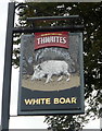
The "White Boar" Radcliffe Road, Bury
Image: © Alexander P Kapp
Taken: 13 Aug 2007
0.05 miles
5

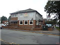
Radcliffe Road Baptist Church
For those of you that like a description - it's on ... err ... Radcliffe Road.
Image: © JThomas
Taken: 10 Sep 2018
0.07 miles
6

Flooded field, Bury
Consecutive days of heavy rain caused this particular area to carry standing water.
Image: © Bradley Michael
Taken: 1 Apr 2015
0.16 miles
8
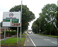
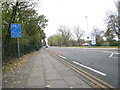
Bury FC sign
Viewed across the A56 Manchester Road from the corner of Gigg Lane. Looking at first glance like a town boundary sign, the sign shows Bury Football Club and gives details of the next match and ticket prices. Bury FC's ground is in Gigg Lane.
Image: © Jaggery
Taken: 6 Oct 2013
0.21 miles
9
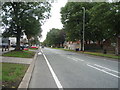
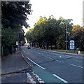
Manchester Road
The A56 into Bury. Turn right for Bury FC, Gigg Lane.
Image: © Gerald England
Taken: 30 Aug 2019
0.22 miles
10
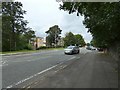
Manchester Road, Bury - 4-11-2008
The A56 Manchester Road, near to its junction with Gigg Lane.
Image: © Duncan Watts
Taken: 4 Nov 2008
0.22 miles