IMAGES TAKEN NEAR TO
Parkhills Road, BURY, BL9 9AT
Introduction
This page details the photographs taken nearby to Parkhills Road, BL9 9AT by members of the Geograph project.
The Geograph project started in 2005 with the aim of publishing, organising and preserving representative images for every square kilometre of Great Britain, Ireland and the Isle of Man.

There are currently over 7.5m images from over14,400 individuals and you can help contribute to the project by visiting https://www.geograph.org.uk
Image Map
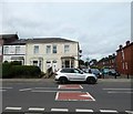
Images are licensed for reuse under creativecommons.org/licenses/by-sa/2.0
Notes
- Clicking on the map will re-center to the selected point.
- The higher the marker number, the further away the image location is from the centre of the postcode.
Image Listing (89 Images Found)
Images are licensed for reuse under creativecommons.org/licenses/by-sa/2.0
Image
Details
Distance
1

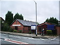
Horne Street
Parkhills Pentecostal church to the right of the picture and in the distance on the left Bury Football Club's Gigg Lane ground.
Image: © Dennis Turner
Taken: 24 Jan 2003
0.01 miles
2
Fishpool Seventh Day Adventist Community Church, Parkhills Road, Bury
Image: © Alexander P Kapp
Taken: 13 Aug 2007
0.02 miles
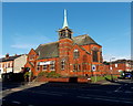
3
Bethesda Pentecostal Church, Bury
Formerly Parkhills Methodist Church.
Image: © JThomas
Taken: 10 Sep 2018
0.03 miles

6
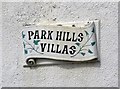
Park Hills Villas: Name plaque
Name plaque on Park Hills Villas Image
Image: © Gerald England
Taken: 30 Aug 2019
0.03 miles
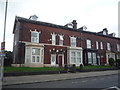
7
Park Hills Villas
The houses on the corner of Park Hills Road and Devon Street are known as Park Hills Villas Image
Image: © Gerald England
Taken: 30 Aug 2019
0.03 miles
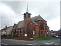
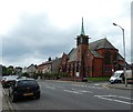
8
Bethesda Pentecostal Church, Bury
Viewed across Parkhills Road. The church, on the corner of Horne Street, was formerly Parkhills Methodist Church which closed in 1966.
Image: © Jaggery
Taken: 6 Oct 2013
0.03 miles
9
Park Hills Road
The church on the right was Parkhills United Free Methodist Church which opened in 1883 and closed in 1966. It later became Bethesda Pentecostal Church. Now it is the Metro Christian Centre https://www.mccbury.org.uk/ which also runs Little Acorns Preschool http://www.littleacornspreschool.org.uk/
Image: © Gerald England
Taken: 30 Aug 2019
0.03 miles
10
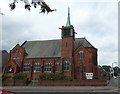
Bethesda Church
Originally this was Parkhills United Free Methodist Church which opened in 1883 and closed in 1966. It later became Bethesda Pentecostal Church. Now the building is used by the Metro Christian Centre https://www.mccbury.org.uk/ who also run Little Acorns Preschool http://www.littleacornspreschool.org.uk/
Image: © Gerald England
Taken: 30 Aug 2019
0.03 miles