IMAGES TAKEN NEAR TO
Braewood Close, BURY, BL9 7PG
Introduction
This page details the photographs taken nearby to Braewood Close, BL9 7PG by members of the Geograph project.
The Geograph project started in 2005 with the aim of publishing, organising and preserving representative images for every square kilometre of Great Britain, Ireland and the Isle of Man.

There are currently over 7.5m images from over14,400 individuals and you can help contribute to the project by visiting https://www.geograph.org.uk
Image Map
Images are licensed for reuse under creativecommons.org/licenses/by-sa/2.0
Notes
- Clicking on the map will re-center to the selected point.
- The higher the marker number, the further away the image location is from the centre of the postcode.
Image Listing (12 Images Found)
Images are licensed for reuse under creativecommons.org/licenses/by-sa/2.0
Image
Details
Distance
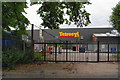
2
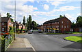
A row of shops on Topping Fold Road
Rather than leave empty shop units, some of the space has been taken over by a community centre.
Image: © Bill Boaden
Taken: 4 Aug 2010
0.11 miles
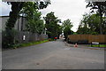
3
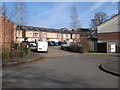
Pavilion Court
New housing on the old enclosure of Bridge Hall. See Image for details of Bridge Hall.
Image: © Jonathan Wilkins
Taken: 24 Feb 2018
0.11 miles
4
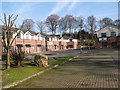
The Pavilions
A small development of business premises on Bridge Hall Road, within the old enclosure of Bridge Hall. See Image for details of Bridge Hall.
Image: © Jonathan Wilkins
Taken: 24 Feb 2018
0.13 miles
5
Bridge Hall Lane
This road was a problem for a while because it was unadopted and nobody was taking responsibility. Now that new housing has been built, it must now be adopted. Here is its junction with Bridgehall Drive which is a newer road.
Image: © Bill Boaden
Taken: 4 Aug 2010
0.14 miles
6
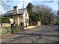
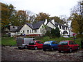
Lodge house, Bridge Hall
A very pleasing house on Bridge Hall Lane, and the only remnant of Bridge Hall which occupied land just to the north-west. Bridge Hall was associated with adjacent paper mills on the River Roch, home to a number of such businesses such as Gigg Mills, downstream. The Hall was demolished in 1954 after requisition by the National Fire Service from 1939, the last time that it was occupied by the Wrigley family. The original (Old) Bridge Hall stands adjacent still.
Image: © Jonathan Wilkins
Taken: 24 Feb 2018
0.14 miles
7
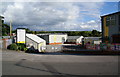
J2 Business Park
The name refers to its proximity to the M66 motorway.
Image: © Bill Boaden
Taken: 4 Aug 2010
0.18 miles
8
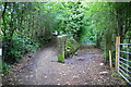
Path junction near Topping Fold
Judging by the gate posts, these paths were more active in the past.
Image: © Bill Boaden
Taken: 4 Aug 2010
0.19 miles
10
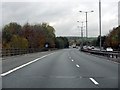
M66 Over Junction 2
The M66 - now just 2 lanes wide - at one of the bridges over the A58.
Image: © Peter Whatley
Taken: 28 Oct 2009
0.24 miles