IMAGES TAKEN NEAR TO
Birchfield Avenue, BURY, BL9 7JF
Introduction
This page details the photographs taken nearby to Birchfield Avenue, BL9 7JF by members of the Geograph project.
The Geograph project started in 2005 with the aim of publishing, organising and preserving representative images for every square kilometre of Great Britain, Ireland and the Isle of Man.

There are currently over 7.5m images from over14,400 individuals and you can help contribute to the project by visiting https://www.geograph.org.uk
Image Map
Images are licensed for reuse under creativecommons.org/licenses/by-sa/2.0
Notes
- Clicking on the map will re-center to the selected point.
- The higher the marker number, the further away the image location is from the centre of the postcode.
Image Listing (39 Images Found)
Images are licensed for reuse under creativecommons.org/licenses/by-sa/2.0
Image
Details
Distance
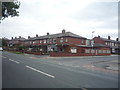
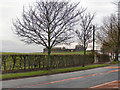
2
Bury Old Road towards Heywood
Looking north east.
Image: © JThomas
Taken: 10 Sep 2018
0.05 miles
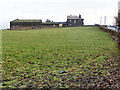
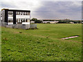
3
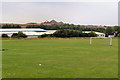
Heywood Community School Playing Fields, July 2010
Sutherland High School, on Sutherland Road at Darnhill, was opened in 1966. Its name was changed to Heywood Community School in the 1990s. The school closed in June 2010 (http://menmedia.co.uk/heywoodadvertiser/news/s/1193762_school_party_to_mark_the_end_of_an_era - Heywood Advertiser and http://news.bbc.co.uk/local/manchester/hi/people_and_places/newsid_8940000/8940501.stm - BBC Education), and was demolished during the winter of 2010-11.
Image: © David Dixon
Taken: 19 Jul 2010
0.08 miles
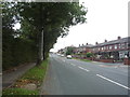
4
Bury Old Road
Looking towards Heap Fold Farm.
Image: © David Dixon
Taken: 4 Feb 2010
0.10 miles
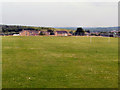
5
Heywood Community School RoSLA Block and Playing Fields (2010)
Sutherland High School, on Sutherland Road at Darnhill, was opened in 1966. Its name was changed to Heywood Community School in the 1990s. The block on the left was built in the early 1970s when the school-leaving age was raised from 15 to 16 (RoSLA).
Closed in June 2010 (http://menmedia.co.uk/heywoodadvertiser/news/s/1193762_school_party_to_mark_the_end_of_an_era - Heywood Advertiser and http://news.bbc.co.uk/local/manchester/hi/people_and_places/newsid_8940000/8940501.stm - BBC Education), the school was demolished during the winter of 2010-11 and, by 2014, a development of new houses was being built. There is now little or no evidence to show that the school buildings once stood on this site.
Image: © David Dixon
Taken: 19 Jul 2010
0.11 miles
6
Heywood Community (Sutherland) High School Main Block - July 2010
Sutherland High School, on Sutherland Road at Darnhill, was opened in 1966. Its name was changed to Heywood Community School in the 1990s.
Closed in June 2010 (http://menmedia.co.uk/heywoodadvertiser/news/s/1193762_school_party_to_mark_the_end_of_an_era - Heywood Advertiser and http://news.bbc.co.uk/local/manchester/hi/people_and_places/newsid_8940000/8940501.stm - BBC Education), the school was demolished during the winter of 2010-11 and, by 2014, a development of new houses was being built. There is now little or no evidence to show that the school buildings once stood on this site.
This photo was taken after the school closed to students in July 2010.
Image: © David Dixon
Taken: 19 Jul 2010
0.11 miles
7
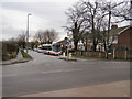
Bury Old Road
Bury Old Road at the junction with Heap Brow and Moss Hall Road.
Image: © David Dixon
Taken: 4 Feb 2010
0.12 miles
8
Heywood Community (Sutherland) High School Playing Fields
Sutherland High School, on Sutherland Road at Darnhill, was opened in 1966. Its name was changed to Heywood Community High School in the 1990s. The school was closed in June 2010 (http://menmedia.co.uk/heywoodadvertiser/news/s/1193762_school_party_to_mark_the_end_of_an_era - Heywood Advertiser and http://news.bbc.co.uk/local/manchester/hi/people_and_places/newsid_8940000/8940501.stm - BBC Education) and was demolished during the winter of 2010-11.
Image: © David Dixon
Taken: 19 Jul 2010
0.14 miles
9
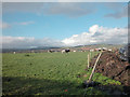
Heap Fold Farm
Farmland in the west of the grid square between Heady Hill and Prettywood. Just left of centre in the distance is Knowl Moor.
Image: © Dennis Turner
Taken: 9 Nov 2005
0.14 miles