IMAGES TAKEN NEAR TO
Holly Street, BURY, BL9 7BS
Introduction
This page details the photographs taken nearby to Holly Street, BL9 7BS by members of the Geograph project.
The Geograph project started in 2005 with the aim of publishing, organising and preserving representative images for every square kilometre of Great Britain, Ireland and the Isle of Man.

There are currently over 7.5m images from over14,400 individuals and you can help contribute to the project by visiting https://www.geograph.org.uk
Image Map
Images are licensed for reuse under creativecommons.org/licenses/by-sa/2.0
Notes
- Clicking on the map will re-center to the selected point.
- The higher the marker number, the further away the image location is from the centre of the postcode.
Image Listing (79 Images Found)
Images are licensed for reuse under creativecommons.org/licenses/by-sa/2.0
Image
Details
Distance
1
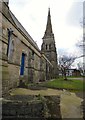
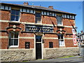
St Thomas's: Churchyard on north side
The Parish Church of St Thomas, at the corner of Pimhole Road and Rochdale Road, was a gift from Thomas Openshaw a local mill owner. Amongst other things, it was built to serve the rows of mill houses that surrounded the church. It is built in the mediaeval style or that period of Gothic architecture known as Early English and the Church spire rises to 120 feet. The Church was consecrated on the 10th December 1866 and the first vicar was Reverend Thomas Atherton.
Image: © Gerald England
Taken: 4 Feb 2017
0.06 miles
3
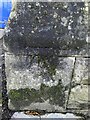
OS Cut Mark - Bury St Thomas' Church
https://www.bench-marks.org.uk/bm85894
Image: © thejackrustles
Taken: 3 Nov 2021
0.07 miles
4
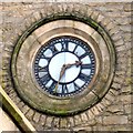
St Thomas's clock
The eastern clock face in St Thomas's Image
Image: © Gerald England
Taken: 4 Feb 2017
0.07 miles
5
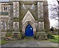
Entrance to St Thomas's Church
The entrance to St Thomas's Image
Image: © Gerald England
Taken: 4 Feb 2017
0.07 miles
6
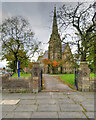
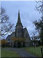
Bury, The Parish Church of Saint Thomas
Built in 1866 in early-English style, the Parish Church of St Thomas is at the corner of Pimhole Road and Rochdale Road. The church spire rises to a height of 129 feet.
The Church was declared a Grade II listed building in 1985 (https://historicengland.org.uk/listing/the-list/list-entry/1067250 Historic England List Entry Number: 1067250).
Image: © David Dixon
Taken: 17 Oct 2020
0.07 miles
7
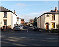
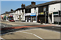
Myrtle Street South, Bury
Viewed across the A58 Rochdale Road.
Image: © Jaggery
Taken: 6 Oct 2013
0.07 miles
8
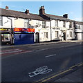
Bury: The 'Turf'
Appears to be apub that has been closed and then re-opened. But for how long?
Image: © Dr Neil Clifton
Taken: 4 Jun 2013
0.07 miles
9
Peel Hotel, Bury
The hotel on the right is at 181 Rochdale Road in the Pimhole area of Bury.
It is probably named after a famous native of Bury, Sir Robert Peel. http://www.geograph.org.uk/photo/3188348
Image: © Jaggery
Taken: 6 Oct 2013
0.07 miles