IMAGES TAKEN NEAR TO
Sycamore Drive, BURY, BL9 6TQ
Introduction
This page details the photographs taken nearby to Sycamore Drive, BL9 6TQ by members of the Geograph project.
The Geograph project started in 2005 with the aim of publishing, organising and preserving representative images for every square kilometre of Great Britain, Ireland and the Isle of Man.

There are currently over 7.5m images from over14,400 individuals and you can help contribute to the project by visiting https://www.geograph.org.uk
Image Map (Loading...)


Getting Data...Please wait
Leaflet Map data © OpenStreetMap
Images are licensed for reuse under creativecommons.org/licenses/by-sa/2.0
Notes
- Clicking on the map will re-center to the selected point.
- The higher the marker number, the further away the image location is from the centre of the postcode.
Image Listing (8 Images Found)
Images are licensed for reuse under creativecommons.org/licenses/by-sa/2.0
Image
Details
Distance
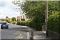
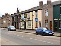
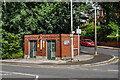
2
Walmersley Road, Limefield
There are some surviving shops, but far fewer than there used to be.
Image: © Bill Boaden
Taken: 6 Jun 2010
0.14 miles
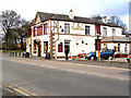
4
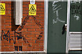
WWII Lancashire: Ghost Signs of the Home Front (16)
-
Emergency Rendezvous Point, Walmersley Road, Bury, at junction with Mather Road
"ERP ---?"
Emergency Rendezvous Points (ERP) were designated places in the locality for the coordination of ARP and emergency services during civil emergencies, particularly for those services arriving from outside the area. The signs appear in a variety of designs, but most are diamond shapes framing the ERP locality number.
Image
Image: © Mike Searle
Taken: 13 Aug 2021
0.19 miles
5
WWII Lancashire: Ghost Signs of the Home Front (17)
-
Emergency Rendezvous Point, Walmersley Road, Bury, at junction with Mather Road
"ERP ---?"
Emergency Rendezvous Points (ERP) were designated places in the locality for the coordination of ARP and emergency services during civil emergencies, particularly for those services arriving from outside the area. The signs appear in a variety of designs, but most are diamond shapes framing the ERP locality number.
Image
Image: © Mike Searle
Taken: 13 Aug 2021
0.19 miles
6
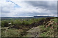
A disused quarry
Now open for leisure walks. There has recently been a fire which has burned a lot of the undergrowth.
Image: © Bill Boaden
Taken: 3 May 2010
0.20 miles
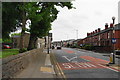
7
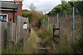
Bury: An overdrown bridleway
Looking north at the east end of Lowes Road. I doubt whether this bridleway has seen a horse in years, and probably few pedestrians either.
Image: © Dr Neil Clifton
Taken: 4 Aug 2013
0.22 miles