IMAGES TAKEN NEAR TO
Bury Old Road, BURY, BL9 6SY
Introduction
This page details the photographs taken nearby to Bury Old Road, BL9 6SY by members of the Geograph project.
The Geograph project started in 2005 with the aim of publishing, organising and preserving representative images for every square kilometre of Great Britain, Ireland and the Isle of Man.

There are currently over 7.5m images from over14,400 individuals and you can help contribute to the project by visiting https://www.geograph.org.uk
Image Map
Images are licensed for reuse under creativecommons.org/licenses/by-sa/2.0
Notes
- Clicking on the map will re-center to the selected point.
- The higher the marker number, the further away the image location is from the centre of the postcode.
Image Listing (21 Images Found)
Images are licensed for reuse under creativecommons.org/licenses/by-sa/2.0
Image
Details
Distance
1
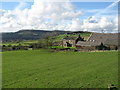
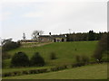
Higher Sedger Hey Farm Nangreaves
Just to the north of the village of Nangreaves http://www.nangreaves.com/%5Cweb%5Cnangreaves.nsf is Higher Sedger Hey Farm seen here in the foreground.
The monument on top of the hill in the distance is Image]
Image: © Paul Anderson
Taken: 3 Mar 2007
0.03 miles
2
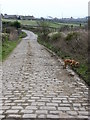
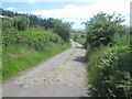
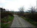
Bury Old Road
Old cobbled road leading to Nangreaves
Image: © liz dawson
Taken: 24 Mar 2007
0.05 miles
3
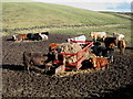
Feeding Time
Just north to the village of Nangreaves next to Bury Old Road these cows take a well earned break in the winter sun.
Image: © Paul Anderson
Taken: 3 Mar 2007
0.08 miles
5
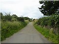
Bury Old Road
The road changes to a cobbled road after passing Butcher Acre Farm
Image: © Kevin Waterhouse
Taken: 27 Jul 2024
0.11 miles
6
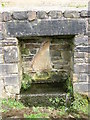
Unusual water trough
Trough adjacent to Bury Old Road
Image: © liz dawson
Taken: 24 Mar 2007
0.12 miles
8
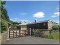
House near A56
From 1 in 25,000 this looks like Top o' the Hoof Farm
Image: © liz dawson
Taken: 24 Mar 2007
0.17 miles
9
Pike Wood to Mount Pleasant
Taken on the track leading down to Pike Wood and Pike Farm and looking back towards Mount Pleasant, Nangreaves, Lancashire.
Image: © Carroll Pierce
Taken: 20 Apr 2013
0.17 miles