IMAGES TAKEN NEAR TO
Bullfinch Drive, BURY, BL9 6JR
Introduction
This page details the photographs taken nearby to Bullfinch Drive, BL9 6JR by members of the Geograph project.
The Geograph project started in 2005 with the aim of publishing, organising and preserving representative images for every square kilometre of Great Britain, Ireland and the Isle of Man.

There are currently over 7.5m images from over14,400 individuals and you can help contribute to the project by visiting https://www.geograph.org.uk
Image Map
Images are licensed for reuse under creativecommons.org/licenses/by-sa/2.0
Notes
- Clicking on the map will re-center to the selected point.
- The higher the marker number, the further away the image location is from the centre of the postcode.
Image Listing (6 Images Found)
Images are licensed for reuse under creativecommons.org/licenses/by-sa/2.0
Image
Details
Distance
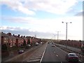
2
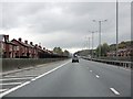
Slicing through the houses
In my opinion, one of the worst pieces of road building in the UK. At this point east of Bury, the M66 was built decidedly "on the cheap", leaving houses on both sides within a few feet of the carriageway, their neighbourhood rent asunder, an inadequate hard shoulder and only two lanes despite the steep climb. In the distance, the road gains a much-needed crawler lane for slower traffic.
Image: © Peter Whatley
Taken: 28 Oct 2009
0.08 miles
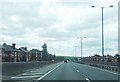
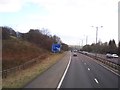
4
Bury : M66 Motorway
Heading along the M66 motorway.
Image: © Lewis Clarke
Taken: 27 Sep 2019
0.16 miles
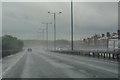
6
M66 passing through housing estate near Bury
View southbound
Image: © Raymond Knapman
Taken: 26 Jan 2012
0.17 miles