IMAGES TAKEN NEAR TO
Arley Avenue, BURY, BL9 5HG
Introduction
This page details the photographs taken nearby to Arley Avenue, BL9 5HG by members of the Geograph project.
The Geograph project started in 2005 with the aim of publishing, organising and preserving representative images for every square kilometre of Great Britain, Ireland and the Isle of Man.

There are currently over 7.5m images from over14,400 individuals and you can help contribute to the project by visiting https://www.geograph.org.uk
Image Map
Images are licensed for reuse under creativecommons.org/licenses/by-sa/2.0
Notes
- Clicking on the map will re-center to the selected point.
- The higher the marker number, the further away the image location is from the centre of the postcode.
Image Listing (38 Images Found)
Images are licensed for reuse under creativecommons.org/licenses/by-sa/2.0
Image
Details
Distance
1
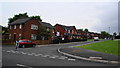
Spinney Drive, Bury
The houses are decorated ready for the World Cup football which starts in a week's time.
Image: © Bill Boaden
Taken: 6 Jun 2010
0.05 miles
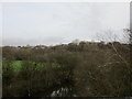
2
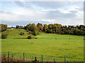
Parkland beside the line
In the vicinity of Higher Woodhill, viewed from a train on the East Lancs Railway.
Image: © John Lucas
Taken: 27 Oct 2022
0.08 miles
3
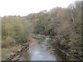
The River Irwell below Higher Woodhill
Image: © Jonathan Thacker
Taken: 23 Jan 2016
0.11 miles
4
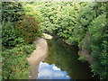
The River Irwell near Higher Woodhill
Looking upstream [locally north-east].
Image: © Christine Johnstone
Taken: 6 Sep 2018
0.12 miles
5
Houses in Plumpton Drive, Limefield, Bury
With a fine view west over the Irwell valley.
Image: © Christine Johnstone
Taken: 6 Sep 2018
0.14 miles
7
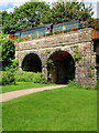
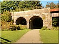
City of Wells Crossing the Calrows Viaduct at Burrs Country Park
Preserved former British Railways Bulleid 7P5FA 4-6-2 ‘West Country’ class locomotive number 34092 ‘City of Wells’ pulls an East Lancashire Railway's steam train across the viaduct at Burrs Park.
Image: © David Dixon
Taken: 31 Jul 2016
0.14 miles
8
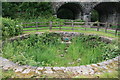
Gas holder 'tank', Higher Woodhill Mill site
This would have been filled with water to provide the water seal on the gas holder that was associated with this mill. An important survivor. This is all in the Burrs Country Park but to date the Geograph photographers have concentrated on the Burrs Mill site at the other end of the park.
Image: © Chris Allen
Taken: 4 Jul 2009
0.15 miles
9
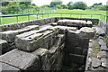
Beam engine foundations, Higher Woodhill Mill site
Bed for a 100 horsepower beam engine (allegedly 100 horsepower). The crankpit is closest with the cross wall to support the columns for the entablature in the middle and the cylinder pad beyond. This looks like it was a single cylinder engine on the available evidence.
Image: © Chris Allen
Taken: 4 Jul 2009
0.17 miles
10
The River Irwell and How Lane
How Lane is a track which at this point runs alongside the River Irwell.
Image: © Jonathan Thacker
Taken: 23 Jan 2016
0.17 miles