IMAGES TAKEN NEAR TO
Waterloo Court, BURY, BL9 0UE
Introduction
This page details the photographs taken nearby to Waterloo Court, BL9 0UE by members of the Geograph project.
The Geograph project started in 2005 with the aim of publishing, organising and preserving representative images for every square kilometre of Great Britain, Ireland and the Isle of Man.

There are currently over 7.5m images from over14,400 individuals and you can help contribute to the project by visiting https://www.geograph.org.uk
Image Map
Images are licensed for reuse under creativecommons.org/licenses/by-sa/2.0
Notes
- Clicking on the map will re-center to the selected point.
- The higher the marker number, the further away the image location is from the centre of the postcode.
Image Listing (66 Images Found)
Images are licensed for reuse under creativecommons.org/licenses/by-sa/2.0
Image
Details
Distance
1
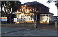
Bury Catholic Preparatory School
Viewed across Manchester Road from the corner of Wellington Road. The school's website states
"The school is proud of its Catholic origins, and enters fully into preparation of children for the Sacraments of Initiation. Children of all denominations are welcomed and encouraged and we actively develop in all children a deep respect and understanding of other faiths and beliefs."
Image: © Jaggery
Taken: 6 Oct 2013
0.03 miles
2
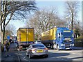
Dachser HGVs on Manchester Road
Two Dachser HGVs pass near Manchester Road Park in Bury.
Dachser is a German logistics group with headquarters in Kempten in the Allgäu. It was founded by Thomas Dachser in 1930. The company has been established in the UK since 1975, operating from three locations. These vehicles are probably based at the Chichester Street depot in Rochdale.
Image: © David Dixon
Taken: 7 Mar 2014
0.04 miles
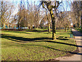
5

Bury Cricket Club
Bury CC are part of Bury Sports Club which also includes Rugby Union and Squash at the Radcliffe Road site.
Image: © BatAndBall
Taken: 16 May 2012
0.08 miles
7

Bury Cricket Club - Scoreboard
Bury Cricket Club play in the Manchester & District Cricket Association Premier Division.
Image: © BatAndBall
Taken: 16 May 2012
0.09 miles
8

Terraced Houses Fishpool
When these terraced houses were first built, the area became known as "Piano Town." This was because with their front gardens, the streets resembled pianos when viewed in plan view on a map.
Image: © Dennis Turner
Taken: 21 Jan 2003
0.10 miles
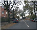
9
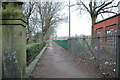
School Footpath
Footpath leads from Wellington Road to Parliament Street Bury. Bordering the eastern boundary of Manchester Road park, it has been used by generations of school students.
Image: © Dennis Turner
Taken: 21 Jan 2003
0.11 miles
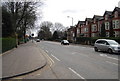
10
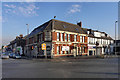
Pack Horse Hotel
A large pub/hotel (currently closed) at the junction of Parkhills Road and Manchester Road (A56), in the Fishpool area of Bury.
Image: © David Dixon
Taken: 17 Jan 2012
0.12 miles