IMAGES TAKEN NEAR TO
The Rock, BURY, BL9 0NU
Introduction
This page details the photographs taken nearby to The Rock, BL9 0NU by members of the Geograph project.
The Geograph project started in 2005 with the aim of publishing, organising and preserving representative images for every square kilometre of Great Britain, Ireland and the Isle of Man.

There are currently over 7.5m images from over14,400 individuals and you can help contribute to the project by visiting https://www.geograph.org.uk
Image Map
Images are licensed for reuse under creativecommons.org/licenses/by-sa/2.0
Notes
- Clicking on the map will re-center to the selected point.
- The higher the marker number, the further away the image location is from the centre of the postcode.
Image Listing (1359 Images Found)
Images are licensed for reuse under creativecommons.org/licenses/by-sa/2.0
Image
Details
Distance
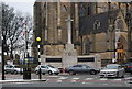
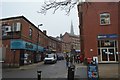
1
The Rock
The original course of the A56, before the Inner ring road was built.
Image: © N Chadwick
Taken: 20 Dec 2008
0.01 miles

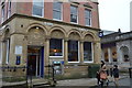
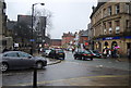
8
The western end of The Rock
The Rock is still Bury's main street. This end has fewer shops and more financial organisations and pubs.
Image: © Bill Boaden
Taken: 31 Dec 2009
0.02 miles
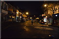
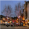
9
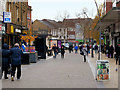
Bury, The Rock
Looking west along the pedestrianised section of The Rock.
Image: © David Dixon
Taken: 15 Nov 2019
0.02 miles