IMAGES TAKEN NEAR TO
The Rock, BURY, BL9 0NE
Introduction
This page details the photographs taken nearby to The Rock, BL9 0NE by members of the Geograph project.
The Geograph project started in 2005 with the aim of publishing, organising and preserving representative images for every square kilometre of Great Britain, Ireland and the Isle of Man.

There are currently over 7.5m images from over14,400 individuals and you can help contribute to the project by visiting https://www.geograph.org.uk
Image Map
Images are licensed for reuse under creativecommons.org/licenses/by-sa/2.0
Notes
- Clicking on the map will re-center to the selected point.
- The higher the marker number, the further away the image location is from the centre of the postcode.
Image Listing (294 Images Found)
Images are licensed for reuse under creativecommons.org/licenses/by-sa/2.0
Image
Details
Distance
1
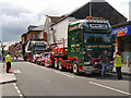
The Rock
Two HGVs belonging to Smiths of Bury, parked on The Rock after taling part in the 2012 Carnival Day parade.
Image: © David Dixon
Taken: 10 Jun 2012
0.01 miles
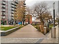
3
The Rock, St John's Gardens
The modern "Rock Triangle" development, which opened in 2010, includes 408 one and two-bedroom apartments located above the shops.
Image: © David Dixon
Taken: 24 Jul 2020
0.02 miles
4

Empty retail unit, The Rock, Bury
This eye-catching window covering hides the interior of a vacant retail unit, part of a new multi-million-pound retail development.
Image: © michael ely
Taken: 16 Mar 2011
0.02 miles
5
"W H Tracey" Paradise Mill, John Street, Bury BL9 0NH
Image: © Robert Wade
Taken: 22 Jul 2010
0.03 miles
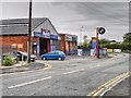
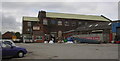
8

Bury - shops at junction of The Rock and John Street
Image: © Dave Bevis
Taken: 15 Nov 2013
0.03 miles
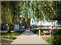
10
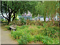
St John's Gardens
The former St John's Church was located off The Rock, then named Stanley Street. The church closed in 1964 but the former graveyard remained. Now, this land forms a garden adjacent to the new Rock Triangle retail and entertainment development which opened in 2010. Several of the gravestones have been retained in the design of the garden alongside the paths.
Image: © David Dixon
Taken: 6 Sep 2021
0.03 miles