IMAGES TAKEN NEAR TO
Spring Vale Drive, BURY, BL8 3SF
Introduction
This page details the photographs taken nearby to Spring Vale Drive, BL8 3SF by members of the Geograph project.
The Geograph project started in 2005 with the aim of publishing, organising and preserving representative images for every square kilometre of Great Britain, Ireland and the Isle of Man.

There are currently over 7.5m images from over14,400 individuals and you can help contribute to the project by visiting https://www.geograph.org.uk
Image Map (Loading...)


Getting Data...Please wait
Leaflet Map data © OpenStreetMap
Images are licensed for reuse under creativecommons.org/licenses/by-sa/2.0
Notes
- Clicking on the map will re-center to the selected point.
- The higher the marker number, the further away the image location is from the centre of the postcode.
Image Listing (49 Images Found)
Images are licensed for reuse under creativecommons.org/licenses/by-sa/2.0
Image
Details
Distance
1
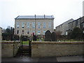
Old school on Wesley Street, Tottington
Now converted into apartments.
Image: © Margaret Clough
Taken: 23 Feb 2006
0.02 miles
2
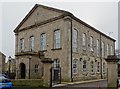
Former school
The building on Wesley Street was originally a Wesleyan day and Sunday school. It has now been converted into apartments.
Image: © philandju
Taken: 19 Feb 2020
0.07 miles

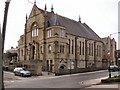
5
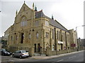
Tottington Methodist Church
This Grade II listed building on Market Street closed in August 2004 for the carrying out of a major scheme of reconstruction.
For over 100 years there has been a church building on this site.
Both buildings had suffered from the ravages of time and in particular the church building had at least a fifty year history of dry rot and had suffered from structural decay and water pressure heave to the lower floor.
Following completion of the scheme, the church reopened for worship in August 2005.
For more information about Tottington Methodist Church click on http://www.tottimeths.org.uk/home.html
Image: © Paul Anderson
Taken: 23 Mar 2007
0.09 miles
6
Tottington Methodist Church
Market Street, Tottington.
Image: © David Dixon
Taken: 8 Apr 2010
0.10 miles
7

Eighteenth century cottages in Tottington
On the edge of the village on Harwood Road.
Image: © philandju
Taken: 17 Jan 2012
0.10 miles
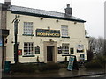
8
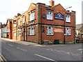
Hark To Towler
The junction of Kirklees Street and Market Street, Tottington.
Image: © David Dixon
Taken: 8 Apr 2010
0.11 miles
9
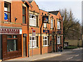
Hark To Towler
Market Street, Tottington.
Image: © David Dixon
Taken: 8 Apr 2010
0.11 miles
10
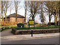
Town Meadow Park
The entrance to Town Meadow Park on Market Street, Tottington.
Image: © David Dixon
Taken: 8 Apr 2010
0.11 miles