IMAGES TAKEN NEAR TO
Turton Road, BURY, BL8 3QH
Introduction
This page details the photographs taken nearby to Turton Road, BL8 3QH by members of the Geograph project.
The Geograph project started in 2005 with the aim of publishing, organising and preserving representative images for every square kilometre of Great Britain, Ireland and the Isle of Man.

There are currently over 7.5m images from over14,400 individuals and you can help contribute to the project by visiting https://www.geograph.org.uk
Image Map
Images are licensed for reuse under creativecommons.org/licenses/by-sa/2.0
Notes
- Clicking on the map will re-center to the selected point.
- The higher the marker number, the further away the image location is from the centre of the postcode.
Image Listing (18 Images Found)
Images are licensed for reuse under creativecommons.org/licenses/by-sa/2.0
Image
Details
Distance
1
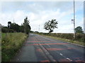
Turton Road
Looking north west on the B6213.
Image: © JThomas
Taken: 17 Sep 2018
0.04 miles
2
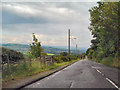
Turton Road
Turton Road, approaching Tottington
Image: © David Dixon
Taken: 27 Aug 2010
0.04 miles
3
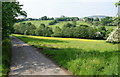
Lane down to Bottoms Hall Farm
Holly Mount is in the trees on the other side of the valley.
Image: © Bill Boaden
Taken: 5 Jun 2010
0.06 miles
4
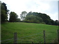
Grazing and woodland off Turton Road, Tottington
Image: © JThomas
Taken: 17 Sep 2018
0.06 miles
5
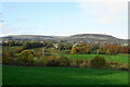
Two Brooks Valley
In the background is Holcombe Moor, with the highest point, Bull Hill, at the back and centre.
Image: © Bill Boaden
Taken: 25 Oct 2020
0.10 miles
6

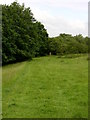
Track to Claybank Cottages
A few metres on from this point, Cann Street, to the right, becomes a footpath.
Image: © philandju
Taken: 17 Jan 2012
0.11 miles
8
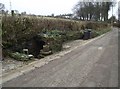
Well on Cann Street
A plaque on the well wall reads "This is the last working well on Cann Street. It is shown on the deeds of No. 38 as circa 1731. It was last used to draw drinking water in the drought of 1976. The well has never been known to run dry and refills in 30 mins. Despite the obvious later additions the original stonework and steps are clearly visible. Please treat with respect this unique historical feature of the old coach road to Tottington."
Image: © philandju
Taken: 17 Jan 2012
0.11 miles
9
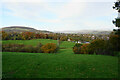
Farmland below Turton Road
Sheep are grazing in Two Brooks Valley. Beyond that are Greenmount and Holcombe Hill, while Scout Moor is in the far background.
Image: © Bill Boaden
Taken: 25 Oct 2020
0.13 miles
10

Footpath and Silver Birch
The path runs between Cann Street and Turton Road. A notice at the further end of the path indicated that it had been closed due to a fallen tree. Now the path is reopened, it's pleasing to see that this two trunked silver birch has survived the recent gales.
Image: © philandju
Taken: 17 Jan 2012
0.14 miles