IMAGES TAKEN NEAR TO
Hulbert Street, BURY, BL8 2NU
Introduction
This page details the photographs taken nearby to Hulbert Street, BL8 2NU by members of the Geograph project.
The Geograph project started in 2005 with the aim of publishing, organising and preserving representative images for every square kilometre of Great Britain, Ireland and the Isle of Man.

There are currently over 7.5m images from over14,400 individuals and you can help contribute to the project by visiting https://www.geograph.org.uk
Image Map
Images are licensed for reuse under creativecommons.org/licenses/by-sa/2.0
Notes
- Clicking on the map will re-center to the selected point.
- The higher the marker number, the further away the image location is from the centre of the postcode.
Image Listing (258 Images Found)
Images are licensed for reuse under creativecommons.org/licenses/by-sa/2.0
Image
Details
Distance
4
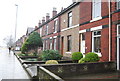
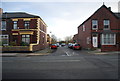
Gentrification of Victorian terraces, Bolton Rd
The stone cladding & double glazing are a clear sign of gentrification.
Image: © N Chadwick
Taken: 20 Dec 2008
0.03 miles
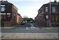
6
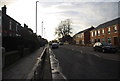
Crompton's terrace, Bolton Rd
Built in 1898.
Image: © N Chadwick
Taken: 21 Mar 2009
0.03 miles
7
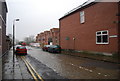
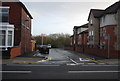
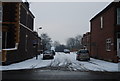
New development on Proctor Street
This road still has its original cobbles.
Image: © N Chadwick
Taken: 20 Dec 2008
0.03 miles
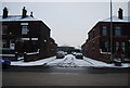
8
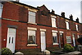
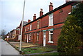
Hampson Terrace, Bolton Rd
A row of terraced houses built in 1890.
Image: © N Chadwick
Taken: 21 Mar 2009
0.03 miles