IMAGES TAKEN NEAR TO
Powell Street, BURY, BL8 2BG
Introduction
This page details the photographs taken nearby to Powell Street, BL8 2BG by members of the Geograph project.
The Geograph project started in 2005 with the aim of publishing, organising and preserving representative images for every square kilometre of Great Britain, Ireland and the Isle of Man.

There are currently over 7.5m images from over14,400 individuals and you can help contribute to the project by visiting https://www.geograph.org.uk
Image Map
Images are licensed for reuse under creativecommons.org/licenses/by-sa/2.0
Notes
- Clicking on the map will re-center to the selected point.
- The higher the marker number, the further away the image location is from the centre of the postcode.
Image Listing (58 Images Found)
Images are licensed for reuse under creativecommons.org/licenses/by-sa/2.0
Image
Details
Distance
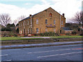
1
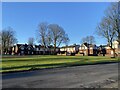
Powell Street
An area of old and sturdy former council housing set round a large green square.
Image: © Bill Boaden
Taken: 22 Feb 2021
0.03 miles
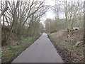
2
Daisyfield Greenway
A cycleway/bridleway along the path of a disused railway (see Image]).
Image: © David Dixon
Taken: 29 Mar 2012
0.04 miles
3
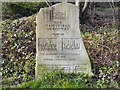
Daisyfield Greenway Marker
This stone marks the Daisyfield Greenway (Image]), a cycle track/bridleway along the path of a disused railway.
Image: © David Dixon
Taken: 29 Mar 2012
0.04 miles
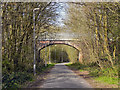
5
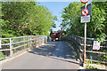
Buller Street Bridge
Bridge over the former railway track (now Daisyfield Greenway). The lane leads to the Cygnet Hospital and then on to Elton Reservoir.
Image: © David Dixon
Taken: 27 May 2020
0.06 miles
6
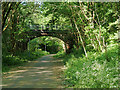
Bridge over Daisyfield Greenway
Daisyfield Greenway (see Image]) is a cycleway/bridleway along the path of the disused railway which ran into Knowsley Street Station in Bury. The line (and the viaduct which carried it across the River Irwell) was closed in the 1970s.
Image: © David Dixon
Taken: 27 May 2020
0.06 miles
7
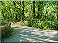
Path Over Brook near Cygnet Hospital
Wooded area surrounding a brook which flows into Elton reservoir.
Image: © David Dixon
Taken: 27 May 2020
0.07 miles
8
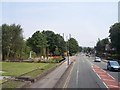
Speed cameras on the A58 outside the Regimental Museum
Image: © Raymond Knapman
Taken: 26 Jul 2012
0.09 miles
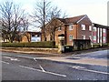
9
Lancashire Fusiliers Headquarters
Last remains of the Wellington Barracks after they were demolished to make way for new housing in the late 1960s. This building was in use as a regimental museum until recently, when the museum transferred to the centre of Bury.
Image]
The space where the Lutyens memorial used to stand in front of the museum (Image]) is now empty as that too has been transferred to the town centre.
Image]
http://www.lancs-fusiliers.co.uk/gallerynew/LFDepots/Wellingtonbarracks/wellingtonBarracks.htm
http://en.wikipedia.org/wiki/Bury
Image: © David Dixon
Taken: 9 Feb 2010
0.11 miles
10
Wellington House
Sheltered accommodation built on the site of the former Wellington Barracks on the corner of Haig Road and Bolton Road.
Image: © David Dixon
Taken: 9 Feb 2010
0.11 miles