IMAGES TAKEN NEAR TO
Longworth Road, BOLTON, BL6 7EU
Introduction
This page details the photographs taken nearby to Longworth Road, BL6 7EU by members of the Geograph project.
The Geograph project started in 2005 with the aim of publishing, organising and preserving representative images for every square kilometre of Great Britain, Ireland and the Isle of Man.

There are currently over 7.5m images from over14,400 individuals and you can help contribute to the project by visiting https://www.geograph.org.uk
Image Map (Loading...)


Getting Data...Please wait
Leaflet Map data © OpenStreetMap
Images are licensed for reuse under creativecommons.org/licenses/by-sa/2.0
Notes
- Clicking on the map will re-center to the selected point.
- The higher the marker number, the further away the image location is from the centre of the postcode.
Image Listing (13 Images Found)
Images are licensed for reuse under creativecommons.org/licenses/by-sa/2.0
Image
Details
Distance
1
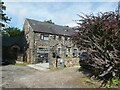
Edge Hill on Bridge Street
A small group of houses on a pot-holed unadopted road alongside Bridge Street Horwich Local Nature Reserve. The house in view incorporates a letting apartment.
Image: © Oliver Dixon
Taken: 2 Aug 2021
0.14 miles
2
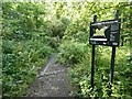
Entrance to Bridge Street Horwich Local Nature Reserve
Well-wooded reserve alongside a stream.
Image: © Oliver Dixon
Taken: 2 Aug 2021
0.15 miles
4
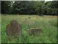
Untended graveyard
Close to the bank of the River Douglas a lower section of the Holy Trinity Church graveyard in Horwich seems sadly neglected. Most of the gravestones I saw in this section commemorated internments in the 1920s.
Image: © Phil and Juliette Platt
Taken: 17 Jun 2011
0.21 miles
5
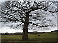
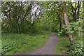
Oak tree near Wilderswood
Looking North towards Rivington Pike.
Image: © Margaret Clough
Taken: 16 Feb 2006
0.21 miles
6
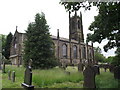
Holy Trinity Church, Horwich
Church of England parish church
Image: © Phil and Juliette Platt
Taken: 17 Jun 2011
0.23 miles
7
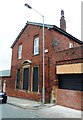
Former Drill Hall
Once the Territorial Army Barracks for the 4th Battalion, Loyal North Lancashire Regiment (F Company)
Image: © Anthony Parkes
Taken: 27 Oct 2014
0.24 miles
8
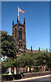
Holy Trinity, Horwich Parish Church
The parish church, on Church Street.
(The flag was flying in honour of the wedding of Prince Charles and Lady Diana Spencer which took place at St Paul's cathedral earlier that day)
Image: © David Dixon
Taken: 29 Jul 1981
0.24 miles
9
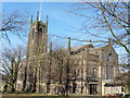
Horwich, Greater Manchester, Holy Trinity
Image: © Dave Kelly
Taken: 24 Feb 2018
0.24 miles
10
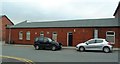
Horwich Resource Centre & Former Drill Hall
Once the Territorial Army Barracks for the 4th Battalion, Loyal North Lancashire Regiment (F Company)
Image: © Anthony Parkes
Taken: 27 Oct 2014
0.25 miles