IMAGES TAKEN NEAR TO
Bolton Road, BOLTON, BL5 3BJ
Introduction
This page details the photographs taken nearby to Bolton Road, BL5 3BJ by members of the Geograph project.
The Geograph project started in 2005 with the aim of publishing, organising and preserving representative images for every square kilometre of Great Britain, Ireland and the Isle of Man.

There are currently over 7.5m images from over14,400 individuals and you can help contribute to the project by visiting https://www.geograph.org.uk
Image Map
Images are licensed for reuse under creativecommons.org/licenses/by-sa/2.0
Notes
- Clicking on the map will re-center to the selected point.
- The higher the marker number, the further away the image location is from the centre of the postcode.
Image Listing (8 Images Found)
Images are licensed for reuse under creativecommons.org/licenses/by-sa/2.0
Image
Details
Distance
1
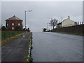
Bolton Road
Heading west - now a cul-de-sac.
Converted water tower on the left.
Image: © JThomas
Taken: 28 Mar 2015
0.07 miles
2
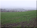
Farmland off Bolton Road
Towards the M61 Motorway.
Image: © JThomas
Taken: 28 Mar 2015
0.10 miles
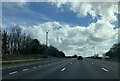
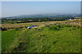
4
Fields for horses by Snydale Hall Farm
At the bottom of the slope, there is standing traffic on the A58 on the stretch between the M61 and the A6.
Image: © Bill Boaden
Taken: 8 Sep 2015
0.13 miles
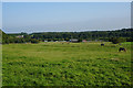
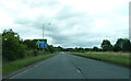
5
Path at Snydale
The short stretch of path is between the covered reservoir at the top of the hill and Bolton Road. There is a good view north to Rivington Pike and Winter Hill.
Image: © Bill Boaden
Taken: 8 Sep 2015
0.15 miles
7
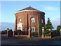
Water Tower, Snydle
A mid 19th century water tower on top of a hill near Westhoughton, called the Snydle. Now converted to a private residence.
Image: © Margaret Clough
Taken: 15 Dec 2005
0.24 miles
8
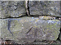
Rivet at base of wall
Rivet: Westhoughton, Bolton Rd (2) RIVET AT BASE OF WALL NO SIDE BOLTON RD.
Image: © Ian Charters
Taken: 5 Apr 2010
0.24 miles