IMAGES TAKEN NEAR TO
Salford Road, BOLTON, BL5 1DB
Introduction
This page details the photographs taken nearby to Salford Road, BL5 1DB by members of the Geograph project.
The Geograph project started in 2005 with the aim of publishing, organising and preserving representative images for every square kilometre of Great Britain, Ireland and the Isle of Man.

There are currently over 7.5m images from over14,400 individuals and you can help contribute to the project by visiting https://www.geograph.org.uk
Image Map
Images are licensed for reuse under creativecommons.org/licenses/by-sa/2.0
Notes
- Clicking on the map will re-center to the selected point.
- The higher the marker number, the further away the image location is from the centre of the postcode.
Image Listing (18 Images Found)
Images are licensed for reuse under creativecommons.org/licenses/by-sa/2.0
Image
Details
Distance
1
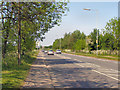
Salford Road
Salford Road (the A6) approaching M61 junction 4 from the east (Nicholas Hill)
Image: © David Dixon
Taken: 23 May 2010
0.07 miles

3
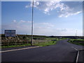
Entrance to Cutacre Tip Reclamation & Surface Mine
Viewed from the A6 Salford Road roundabout, just off the M61, Junction 4.
Image: © Stephen Armstrong
Taken: 14 Aug 2010
0.11 miles
4
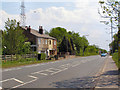
Nicholas Hill
A short stretch of the A6 (Salford Road) has signs for "Nicholas Hill". Not sure if it's a name for the road or the district.
Image: © David Dixon
Taken: 23 May 2010
0.14 miles
5
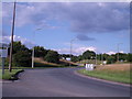
Looking from the A6 Salford Road roundabout towards the M61 Junction 4
Image: © Stephen Armstrong
Taken: 14 Aug 2010
0.15 miles
6
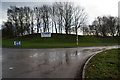
The entrance to Exide, Little Hulton
The landscaped entrance is off Salford Road, the A6.
Image: © Bill Boaden
Taken: 3 Dec 2011
0.16 miles
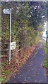
7

Public footpath off the A6
The path is treacherous in parts; not because of the Autumn leaves, but the vegetation on the ground.
Image: © Bradley Michael
Taken: 28 Oct 2015
0.16 miles
8
Path junction, A6
See Image for a view of the public footpath signposted in the image.
Image: © Bradley Michael
Taken: 28 Oct 2015
0.16 miles
9
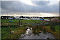
Bridleway ending at Cutacre Tip Reclamation and Surface Mine
The tip reclamation site has grown considerably more than is shown on OS maps, and this bridleway is one that has been swallowed up.
Image: © Bill Boaden
Taken: 3 Dec 2011
0.17 miles
