IMAGES TAKEN NEAR TO
Davies Street, BOLTON, BL4 8DX
Introduction
This page details the photographs taken nearby to Davies Street, BL4 8DX by members of the Geograph project.
The Geograph project started in 2005 with the aim of publishing, organising and preserving representative images for every square kilometre of Great Britain, Ireland and the Isle of Man.

There are currently over 7.5m images from over14,400 individuals and you can help contribute to the project by visiting https://www.geograph.org.uk
Image Map
Images are licensed for reuse under creativecommons.org/licenses/by-sa/2.0
Notes
- Clicking on the map will re-center to the selected point.
- The higher the marker number, the further away the image location is from the centre of the postcode.
Image Listing (37 Images Found)
Images are licensed for reuse under creativecommons.org/licenses/by-sa/2.0
Image
Details
Distance

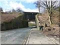
2
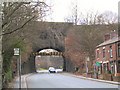
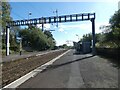
Bridge Reinforcement
The railway bridge at Kearsley station. The line is so high in relation to the road, that the retaining wall had started to bulge. The steel girders are there to reinforce the stability of the embankment, but they limit the height of vehicles which can pass beneath, to 15ft 9ins.
Image: © Roger May
Taken: 14 Dec 2005
0.08 miles
3
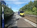
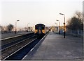
Leaving Kearsley
A Class 150 DMU 150118 on a service from Stalybridge to Southport.
Image: © Gerald England
Taken: 23 Sep 2022
0.10 miles
4
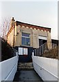
Kearsley station building 1989
A stiff climb up from the road, with more to come. The building's roof is about level with the platform surface.
Image: © Peter Whatley
Taken: 20 Feb 1989
0.10 miles
5
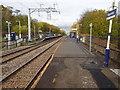
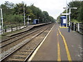
Kearsley railway station, Greater Manchester
Opened in 1838 by the Manchester and Bolton Railway, later part of the Lancashire & Yorkshire Railway, this station was variously called "Ringley" and "Stoneclough" to 1848. It settled on "Stoneclough" from 1848 to 1894, then became "Kearsley & Stoneclough" to 1903, and has been called "Kearsley" since then.
View north west towards Farnworth and Bolton, shortly after the line was electrified.
Image: © Nigel Thompson
Taken: 14 Nov 2018
0.10 miles
6
Kearsley station 1989
The shelters offered little protection from Lancashire's weather. The station was (and is) perched high on a hillside of the Irwell valley.
Image: © Peter Whatley
Taken: 20 Feb 1989
0.10 miles
7
Kearsley Station
Opened in 1838 by the Manchester and Bolton Railway, later part of the Lancashire & Yorkshire Railway, this station was variously called "Ringley" and "Stoneclough" to 1848. It settled on "Stoneclough" from 1848 to 1894, then became "Kearsley & Stoneclough" to 1903, and has been called "Kearsley" since then.
Image: © Gerald England
Taken: 23 Sep 2022
0.11 miles
8
Kearsley railway station, Greater Manchester, 2012
Opened in 1838 by the Manchester and Bolton Railway, later part of the Lancashire & Yorkshire Railway, this station was variously called "Ringley" and "Stoneclough" to 1848. It settled on "Stoneclough" from 1848 to 1894, then became "Kearsley & Stoneclough" to 1903, and has been called "Kearsley" since then.
View north west towards Farnworth and Bolton, a few years before electrification. For an updated view, see Image
Image: © Nigel Thompson
Taken: 13 Oct 2012
0.11 miles
9
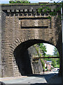
Kearsley - Stoneclough Road bridge below station
For an alternative view of this bridge, please see Image
Image: © Dave Bevis
Taken: 21 May 2012
0.14 miles
10
Stoneclough Road railway bridge at Kearsley
Image: © Raymond Knapman
Taken: 4 Apr 2015
0.14 miles