IMAGES TAKEN NEAR TO
Salisbury Street, BOLTON, BL3 5DR
Introduction
This page details the photographs taken nearby to Salisbury Street, BL3 5DR by members of the Geograph project.
The Geograph project started in 2005 with the aim of publishing, organising and preserving representative images for every square kilometre of Great Britain, Ireland and the Isle of Man.

There are currently over 7.5m images from over14,400 individuals and you can help contribute to the project by visiting https://www.geograph.org.uk
Image Map
Images are licensed for reuse under creativecommons.org/licenses/by-sa/2.0
Notes
- Clicking on the map will re-center to the selected point.
- The higher the marker number, the further away the image location is from the centre of the postcode.
Image Listing (52 Images Found)
Images are licensed for reuse under creativecommons.org/licenses/by-sa/2.0
Image
Details
Distance
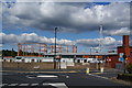
1
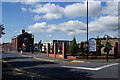
Mayor Street Depot
A depot for the Environmental Services Department of Bolton Council.
Image: © Bill Boaden
Taken: 22 Sep 2012
0.06 miles
2
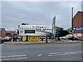
The Steak Out
Steak restaurant made from an airplane fuselage,
Image: © Paul Foster
Taken: 7 Feb 2023
0.06 miles
3
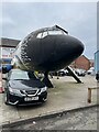
Nose cone of The Steak Out
Airplane nose cone.
Image: © Paul Foster
Taken: 7 Feb 2023
0.07 miles
5
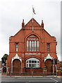
Shree Swaminarayan Mandir, Deane Road
Hindu temple and arts and cultural centre occupying the former Unity Church (Unitarian) on Deane Road. The building is a fine example of late 19th century religious gothic in red brick with terracotta detailing. Remarkably, the Indian style porches do not seem to be out of place.
Image: © Alan Murray-Rust
Taken: 25 Jul 2012
0.11 miles
6
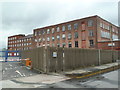
Bolton University - former textile mills
I would be grateful if anybody could tell me more about the name and history of these mills that are now part of Bolton University.
My research to date suggests they are Deane Road Mill - also known as Crook's Mill - dating to 1835. A recent article in the local newspaper states that the University is seeking (again) to demolish this mill and refers to it as Holt's mill. The last owner was Holt Hosiery and that is concordant with the other facts.
Image: © Chris Allen
Taken: 6 Apr 2014
0.12 miles
7
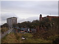
Croal Mill and residential flats
Walk along the cycle track from Lostock station alongside the railway and River Croal passing industrial and residential sites before arriving in Bolton town centre.
Image: © Christine Crompton
Taken: 13 Jan 2009
0.13 miles
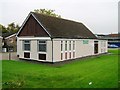
8
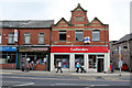
Branch No.29
Former Co-operative store on Deane Road, now a betting shop.
Image: © Alan Murray-Rust
Taken: 25 Jul 2012
0.13 miles
9
Gasholders in Gilnow
In the foreground is a local council vehicle testing station.
Image: © Bill Boaden
Taken: 22 Sep 2012
0.13 miles
10
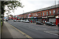
Deane Road
Typical terraced retail development along a suburban main road, including the local post office.
Image: © Alan Murray-Rust
Taken: 25 Jul 2012
0.14 miles