IMAGES TAKEN NEAR TO
Hornby Drive, BOLTON, BL3 4RP
Introduction
This page details the photographs taken nearby to Hornby Drive, BL3 4RP by members of the Geograph project.
The Geograph project started in 2005 with the aim of publishing, organising and preserving representative images for every square kilometre of Great Britain, Ireland and the Isle of Man.

There are currently over 7.5m images from over14,400 individuals and you can help contribute to the project by visiting https://www.geograph.org.uk
Image Map
Images are licensed for reuse under creativecommons.org/licenses/by-sa/2.0
Notes
- Clicking on the map will re-center to the selected point.
- The higher the marker number, the further away the image location is from the centre of the postcode.
Image Listing (26 Images Found)
Images are licensed for reuse under creativecommons.org/licenses/by-sa/2.0
Image
Details
Distance
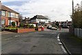
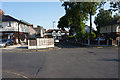
1
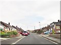
Hornby Drive
A residential cul de sac at Hunger Hill in Bolton.
Image: © philandju
Taken: 7 Aug 2020
0.02 miles
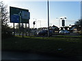
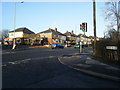
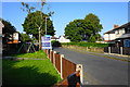
5
Lock Lane, Hunger Hill
Approaching Wigan Road.
Image: © Mark Anderson
Taken: 12 Oct 2019
0.07 miles
7
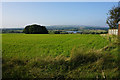
Grassy field on Hunger Hill
The slope leads down to Rumworth Lodge Reservoir with Winter Hill on the skyline.
Image: © Bill Boaden
Taken: 8 Sep 2015
0.08 miles
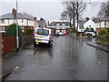
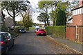
9
Hunger Hill Avenue
Part of a mature housing estate in this satellite village of Bolton. There is no way through to the fields beyond.
Image: © Bill Boaden
Taken: 8 Sep 2015
0.11 miles
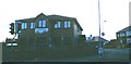
10
Houses for sale on Knutshaw Crescent
A quiet residential road off the A58.
Image: © Bill Boaden
Taken: 8 Sep 2015
0.11 miles