IMAGES TAKEN NEAR TO
Foundry Street, BOLTON, BL3 1HL
Introduction
This page details the photographs taken nearby to Foundry Street, BL3 1HL by members of the Geograph project.
The Geograph project started in 2005 with the aim of publishing, organising and preserving representative images for every square kilometre of Great Britain, Ireland and the Isle of Man.

There are currently over 7.5m images from over14,400 individuals and you can help contribute to the project by visiting https://www.geograph.org.uk
Image Map
Images are licensed for reuse under creativecommons.org/licenses/by-sa/2.0
Notes
- Clicking on the map will re-center to the selected point.
- The higher the marker number, the further away the image location is from the centre of the postcode.
Image Listing (29 Images Found)
Images are licensed for reuse under creativecommons.org/licenses/by-sa/2.0
Image
Details
Distance
1
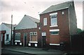
Salvation Army, Fletcher Street
The former Salvation Army hall in Fletcher Street Little Lever is the centre building of this trio of buildings. After the Salvation Army left the hall became a Billiards Hall.
Image: © Rob K Brettle
Taken: Unknown
0.07 miles
3
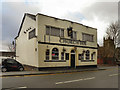
Church Inn, Little Lever
The Church Inn, Market Street, Little Lever. (The tower, to the right of the inn, belongs to The Parish Church of St Matthew).
Image: © David Dixon
Taken: 9 Jan 2011
0.09 miles
4
Church Inn
The Church Inn, Market Street, Little Lever.
Image: © David Dixon
Taken: 9 Jan 2011
0.09 miles
5
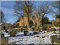
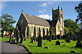
Little Lever, St Matthew's Church and Graveyard
The Parish Church of St Matthew was built in 1865 to replace an earlier church built in 1791 on the other side of the street. The tower was increased in height in 1924 as a memorial to parishioners killed during the First World War (Image]).
Image: © David Dixon
Taken: 22 Jan 2013
0.10 miles
6
St. Matthew's Church and graveyard
Church of England parish church.
Image: © philandju
Taken: 24 Mar 2015
0.10 miles
7
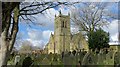
St Matthew's Church and Graveyard, Little Lever
St Matthew's was built in 1865 to replace an earlier church built in 1791 on the other side of the street. The tower was increased in height in 1924 as a memorial to the First World War (Image]).
Image: © David Dixon
Taken: 21 Jan 2013
0.10 miles
8
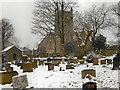
Little Lever, Parish Church of St Matthew
St Matthew's church at Little Lever was built in 1865 to replace an earlier church built in 1791 on the other side of the street. The tower was increased in height in 1924 as a memorial to parishioners killed during the First World War (Image]).
Image: © David Dixon
Taken: 22 Jan 2013
0.10 miles
9
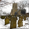
Little Lever, St Matthew's Church
St Matthew's was built in 1865 to replace an earlier church built in 1791 on the other side of the street. The tower was increased in height in 1924 as a memorial to the First World War (Image]).
Image: © David Dixon
Taken: 21 Jan 2013
0.11 miles
10
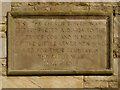
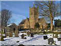
Inscription, St Matthew's Church
Image] was built in 1865, its tower was increased in height in 1924 as a memorial to parishioners killed during the First World War. The inscription reads:
THE CHURCH TOWER WAS
COMPLETED AD 1924 TO THE
GLORY OF GOD AND IN MEMORY
OF THE LITTLE LEVER MEN WHO
DIED FOR THEIR COUNTRY IN
THE GREAT WAR
1914 - 1918
Image: © David Dixon
Taken: 22 Jan 2013
0.11 miles