IMAGES TAKEN NEAR TO
Thirsk Road, BOLTON, BL3 1ET
Introduction
This page details the photographs taken nearby to Thirsk Road, BL3 1ET by members of the Geograph project.
The Geograph project started in 2005 with the aim of publishing, organising and preserving representative images for every square kilometre of Great Britain, Ireland and the Isle of Man.

There are currently over 7.5m images from over14,400 individuals and you can help contribute to the project by visiting https://www.geograph.org.uk
Image Map
Images are licensed for reuse under creativecommons.org/licenses/by-sa/2.0
Notes
- Clicking on the map will re-center to the selected point.
- The higher the marker number, the further away the image location is from the centre of the postcode.
Image Listing (20 Images Found)
Images are licensed for reuse under creativecommons.org/licenses/by-sa/2.0
Image
Details
Distance
1
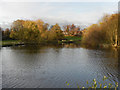
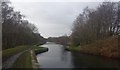
Manchester, Bolton & Bury Canal; Top o? th? Lodge
The canal widens at “Top o’ th’ Lodge” where there used to be a boatyard.
Image: © David Dixon
Taken: 14 Nov 2010
0.14 miles
2
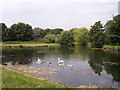
Family of swans on the Manchester,Bolton and Bury Canal
The scene near Little Lever where there is a canal basin
Image: © Raymond Knapman
Taken: 26 Jul 2012
0.15 miles
3
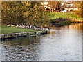
Manchester, Bolton & Bury Canal; Top o? th? Lodge
Image: © David Dixon
Taken: 14 Nov 2010
0.15 miles
4
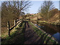
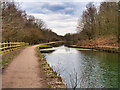
Canal and Towpath
The Bolton spur of the disused Manchester, Bolton, Bury Canal. According to an old mile marker stone beside the towpath, a barge travelling to Manchester from here had eight and a quarter miles to go.
Image: © philandju
Taken: 13 Mar 2012
0.17 miles

8
The Manchester Bolton & Bury Canal narrows
Image: © Bradley Michael
Taken: 29 Jan 2016
0.22 miles
9
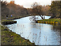
Manchester, Bolton & Bury Canal, Little Lever
The Bolton arm of the canal, behind Ascot Road. There is a groove in each side of the bank the bank at the narrowest point. These were to accommodate stop planks, used when part of the canal was drained.
Image: © David Dixon
Taken: 14 Nov 2010
0.22 miles
10
Bolton Arm of the Manchester Bolton and Bury Canal at Little Lever
The Bolton arm of the canal, behind Ascot Road. There is a groove in each side of the bank at the narrowest point. These were to accommodate stop planks, used when part of the canal was to be drained.
Image: © David Dixon
Taken: 5 Mar 2021
0.22 miles