IMAGES TAKEN NEAR TO
Crossdale Road, BOLTON, BL2 5ND
Introduction
This page details the photographs taken nearby to Crossdale Road, BL2 5ND by members of the Geograph project.
The Geograph project started in 2005 with the aim of publishing, organising and preserving representative images for every square kilometre of Great Britain, Ireland and the Isle of Man.

There are currently over 7.5m images from over14,400 individuals and you can help contribute to the project by visiting https://www.geograph.org.uk
Image Map
Images are licensed for reuse under creativecommons.org/licenses/by-sa/2.0
Notes
- Clicking on the map will re-center to the selected point.
- The higher the marker number, the further away the image location is from the centre of the postcode.
Image Listing (7 Images Found)
Images are licensed for reuse under creativecommons.org/licenses/by-sa/2.0
Image
Details
Distance
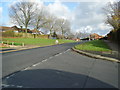
3
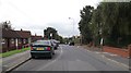
Deepdale Road in Breightmet
At the corner of Red Lane.
Image: © philandju
Taken: 24 Jul 2020
0.20 miles
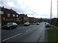
4

Houses on Red Lane
Semi detached houses, probably built between the wars.
Image: © philandju
Taken: 3 Aug 2021
0.20 miles
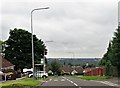
6
Red Lane, Breightmet, Bolton
On the right, substantial inter-wars semi-detached houses, and on the left, old folks' council bungalows, built in the 1960's.
Image: © philandju
Taken: 23 Sep 2011
0.23 miles
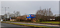
7
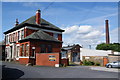
Breightmet Fold House
A surprisingly grand office building as part of the adjoining mill. Some of the units are now vacant.
Image: © Bill Boaden
Taken: 15 Jul 2012
0.25 miles