IMAGES TAKEN NEAR TO
Bradshaw Meadows, BOLTON, BL2 4NF
Introduction
This page details the photographs taken nearby to Bradshaw Meadows, BL2 4NF by members of the Geograph project.
The Geograph project started in 2005 with the aim of publishing, organising and preserving representative images for every square kilometre of Great Britain, Ireland and the Isle of Man.

There are currently over 7.5m images from over14,400 individuals and you can help contribute to the project by visiting https://www.geograph.org.uk
Image Map
Images are licensed for reuse under creativecommons.org/licenses/by-sa/2.0
Notes
- Clicking on the map will re-center to the selected point.
- The higher the marker number, the further away the image location is from the centre of the postcode.
Image Listing (9 Images Found)
Images are licensed for reuse under creativecommons.org/licenses/by-sa/2.0
Image
Details
Distance
1
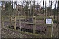
Mysterious structure
The fenced off concrete base with a concrete monument atop is not detailed on the map. It seems that the structure is owned by the Coal Authority and could be a capped mineshaft.
Image: © philandju
Taken: 2 Feb 2013
0.07 miles
3
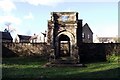
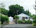
Bradshaw Hall porch
This Jacobean porch is all that remains of Bradshaw Hall, the home of the Bradshaw family from the 12th to the 18th century. Later occupants, the Lomaxes and the Hardcastles developed a bleachworks on the site. The bleachworks in turn is no longer, and has been converted into apartments and houses.
Image: © philandju
Taken: 2 Feb 2013
0.15 miles
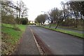
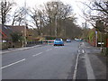
4
New Heys Way
A residential area in Harwood.
Image: © philandju
Taken: 28 Jul 2020
0.17 miles
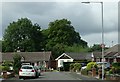
5
New Heys Way becomes Catterall Crescent
A residential area in Harwood.
Image: © philandju
Taken: 28 Jul 2020
0.17 miles
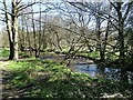
7
Outlet into Bradshaw Brook
Probably a long disused sewer outlet from the now demolished Bradshaw Hall, which stood at the top of the river bank here.
Image: © philandju
Taken: 15 Apr 2021
0.21 miles
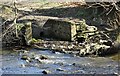
8
Bradshaw Brook, Bradshaw
Upstream from the Rigby Lane crossing there is this small weir.
Image: © philandju
Taken: 28 Oct 2011
0.22 miles
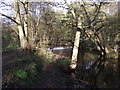
9
Bradshaw Brook
On the Upper Bradshaw Valley Nature Reserve.
Image: © philandju
Taken: 15 Apr 2021
0.24 miles